Al-Shaykh Muwannis
Al-Shaykh Muwannis
الشيخ مونّس Sheikh Muwannis | |
|---|---|
 Bekas rumah dari sheikh desa tersebut, alias "rumah hijau", sekarang bagian dari Universitas Tel Aviv | |
| Etimologi: "The Sheikh Muwannis"[1] | |
 Al-Shaykh Muwannis | |
| Koordinat: 32°06′50″N 34°48′15″E / 32.11389°N 34.80417°E | |
| Grid Palestina | 131/168 |
| Entitas geopolitik | Mandat Palestina |
| Subdistrik | Jaffa |
| Tanggal pengosongan | 30 Maret 1948[4] |
| Luas | |
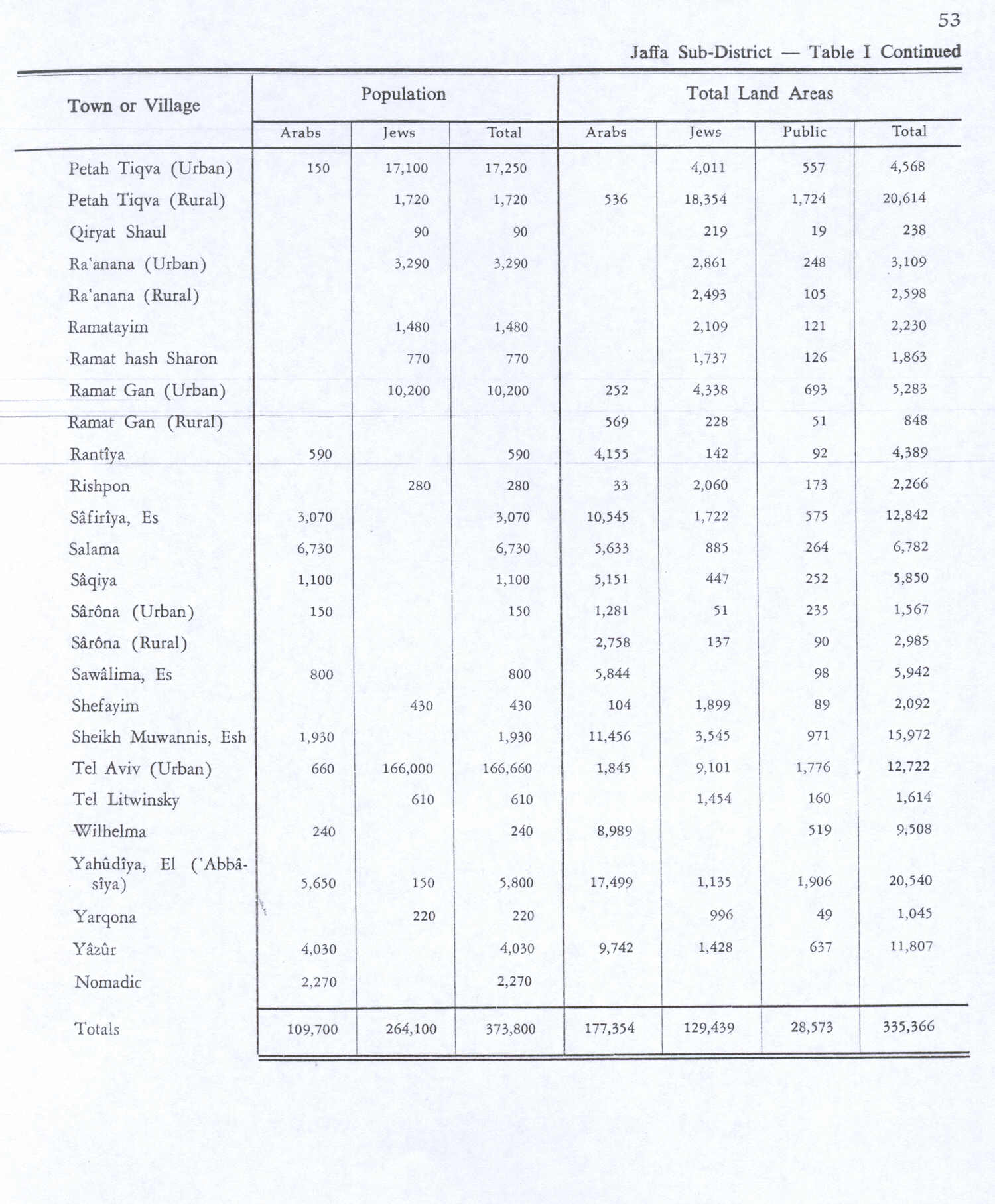
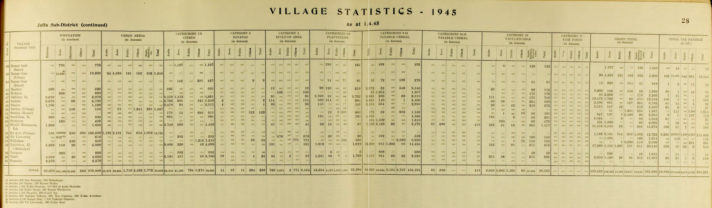
| • Total | 15,972 dunams (15,972 km2 or 6,167 sq mi) |
| Populasi (1945) | |
| • Total | 1.930[2][3] |
| Sebab pengosongan | Serangan militer oleh pasukan Yishuv |
| Sebab sekunder | Khawatir akan ditangkap dalam pertikaian |
| Wilayah saat ini | Tel Aviv |
Al-Shaykh Muwannis (bahasa Arab: الشيخ مونّس), juga Sheikh Munis, adalah sebuah desa Arab Palestina kecil di Subdistrik Jaffa, Mandat Palestina,[5] yang berjarak sekitar 8.5 kilometer dari pusat kota Jaffa di wilayah yang ditandai untuk negara Yahudi di bawah Rencana Partisi PBB.[6] Desa tersebut ditinggalkan pada Maret 1948 karena ancaman dari militia Yahudi, dua bulan sebelum Perang Arab-Israel 1948. Saat ini, Universitas Tel Aviv berada di bagian dari lahan desa tersebut.[5]
Referensi
- ^ Palmer, 1881, p. 218
- ^ Government of Palestine, Department of Statistics. Village Statistics, April, 1945. Quoted in Hadawi, 1970, p. 53
- ^ Government of Palestine, Department of Statistics, 1945, p. 28
- ^ Morris, 2004, p. xviii, village #200. Also gives causes of depopulation.
- ^ a b Daniel Monterescu and Dan Rabinowitz (2007). Mixed Towns, Trapped Communities: Historical Narratives, Spatial Dynamics, Gender Relations and Cultural Encounters in Palestinian-Israeli Towns. Ashgate Publishing, Ltd. hlm. 298. ISBN 0-7546-4732-3.
- ^ Benny Morris (Autumn 1991). "Response to Finkelstein and Masalha". Journal of Palestine Studies. 21 (1): 98–114. doi:10.1525/jps.1991.21.1.00p00682.
Daftar pustaka
- Barron, J.B., ed. (1923). Palestine: Report and General Abstracts of the Census of 1922. Government of Palestine.
- Conder, C.R.; Kitchener, H.H. (1882). The Survey of Western Palestine: Memoirs of the Topography, Orography, Hydrography, and Archaeology. Vol. 2. London: Committee of the Palestine Exploration Fund.
- Government of Palestine, Department of Statistics (1945). Village Statistics, April, 1945.
- Guérin, V. (1875). Description Géographique Historique et Archéologique de la Palestine (dalam bahasa French). Vol. 2: Samarie, pt. 2. Paris: L'Imprimerie Nationale. Pemeliharaan CS1: Bahasa yang tidak diketahui (link)
- Hadawi, S. (1970). Village Statistics of 1945: A Classification of Land and Area ownership in Palestine. Palestine Liberation Organization Research Center. Diarsipkan dari asli tanggal 2018-12-08. Diakses tanggal 2009-02-01.
- Karmon, Y. (1960). "An Analysis of Jacotin's Map of Palestine" (PDF). Israel Exploration Journal. 10 (3, 4): 155–173, 244–253. Diarsipkan dari asli (PDF) tanggal 2019-12-22. Diakses tanggal 2020-07-16.
- Khalidi, W. (1992). All That Remains: The Palestinian Villages Occupied and Depopulated by Israel in 1948. Washington D.C.: Institute for Palestine Studies. ISBN 0-88728-224-5. ISBN 0-88728-224-5.
- Mills, E., ed. (1932). Census of Palestine 1931. Population of Villages, Towns and Administrative Areas. Jerusalem: Government of Palestine.
- Morris, B. (2004). The Birth of the Palestinian Refugee Problem Revisited. Cambridge University Press. ISBN 0-521-00967-7.
- Palmer, E.H. (1881). The Survey of Western Palestine: Arabic and English Name Lists Collected During the Survey by Lieutenants Conder and Kitchener, R. E. Transliterated and Explained by E.H. Palmer. Committee of the Palestine Exploration Fund.
- Pappe, I. (1999). The Israel/Palestine Question. Routledge. ISBN 0-415-16947-X.
- Sand, S. (2012). The Invention of the Land of Israel: From Holy Land to Homeland. Verso Books. ISBN 978-1-84467-946-1.
- Sufian, Sandra Marlene; LeVine, M. (2007). Reapproaching borders: new perspectives on the study of Israel-Palestine. Rowman & Littlefield. ISBN 0-7425-4639-X.
Pranala luar
- Welcome to al-Shaykh-Muwannis,
- Survey of Western Palestine, Map 13: IAA, Wikimedia commons
- Shaykh Muwannis, from Zochrot
- Meeting the bulldozers at the Baydas House, Shaykh Muwannis (Ramat Aviv), Zoroch
- Tel Aviv University is asked to acknowledge its past and to commemorate the Palestinian village on which grounds the university was built, 2003, Zochrot
- al-Shaykh Muwannis tour - report 2003.
- Map, 1946
| Internasional | |
|---|---|
| Nasional | |
Content Disclaimer
Informasi ini disarikan dari Wikipedia dan disajikan kembali untuk tujuan edukasi. Konten tersedia di bawah lisensi CC BY-SA 3.0. Kami tidak bertanggung jawab atas ketidakakuratan data yang bersumber dari kontribusi publik tersebut.
- The information displayed on this website is sourced in part or in whole from Wikipedia and has been adapted for the purpose of restating it. We strive to provide accurate and relevant information, however:
- There is no guarantee of absolute accuracy. Wikipedia is an open, collaborative project that can be edited by anyone, so information is subject to change.
- It is not intended to constitute professional advice. The content displayed is for informational and educational purposes only. For important decisions (e.g., medical, legal, or financial), please consult a professional.
- Content copyright. Wikipedia is licensed under the Creative Commons Attribution-ShareAlike License (CC BY-SA). This means that content may be reused with appropriate attribution and shared under a similar license.
- Responsible use. Any risk arising from the use of information from this website is entirely the responsibility of the user.