Gunung Kamerun
| Gunung Kamerun | |
|---|---|
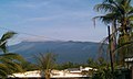
.jpg) Gunung Kamerun dari Buea | |
| Titik tertinggi | |
| Ketinggian | 4.040 m (13.250 ft)[1][2] |
| Puncak | 3.901 m (12.799 ft)[3] Peringkat 31 |
| Isolasi | 2.338 km (1.453 mi) |
| Masuk dalam daftar | Titik tertinggi negara |
| Koordinat | 4°13′00″N 9°10′21″E / 4.21667°N 9.17250°E |
| Penamaan | |
| Nama lokal | Mongo ma Ndemi (Duala) |
| Geografi | |
 Gunung Kamerun Kamerun | |
| Letak | Region Barat Daya, Kamerun |
| Geologi | |
| Jenis gunung | Stratovolcano |
| Letusan terakhir | Februari 2012 |
| Pendakian | |
| Pendakian pertama | Joseph Merrick, 1840[4] |
| Rute termudah | Scrambling |
Gunung Kamerun adalah gunung berapi aktif di wilayah Barat Daya Kamerun di sebelah kota Buea dekat Teluk Guinea. Gunung Kamerun juga dikenal sebagai Fako (nama yang lebih tinggi dari dua puncaknya) atau dengan nama aslinya Mongo ma Ndemi' ' ("Gunung Keagungan").
Gunung ini merupakan titik tertinggi di sub-Sahara Afrika barat dan tengah,[5] Gunung tersebut merupakan bagian dari area aktivitas vulkanik yang dikenal sebagai Garis Vulkanik Kamerun, yang juga mencakup Danau Nyos, tempat terjadinya bencana tahun 1986, dan letusan terbaru terjadi pada 3 Februari 2012.
Galeri
-
 Gunung Fako, tampak kiri
 -
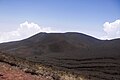
 Pemandangan puncak di Gunung Fako
 -
 Gunung Fako
 -
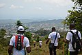
 Pendakian di Gunung Kamerun
 -
 Pemandangan Gunung Kamerun
 -
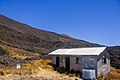
 Pemandangan gunung dari base camp
 -
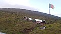 Fasilitas akomodasi di Gunung Fako
 -
 Ditto
Ditto -
 Ditto
Ditto -
Balap Gunung Kamerun
-
 Para pendaki turun
 -
 Pemandangan Gunung Etinde
 -
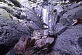 Batuan tropis Gunung Kamerun
 -
 Pantai Limbe
 -
 Membakar Plum


.jpg)


Catatan
- ^ A higher elevation of 4.095 m (13.435 ft) is often given, but this is not compatible with SRTM data, which shows no 3" cells higher than 4.027 m (13.212 ft) or 1" cells higher than 4.029 m (13.219 ft).
- ^ A hand-held GPS reading of 4.045 m (13.271 ft) was reported in 2015.[1] The elevation is subject to change due to volcanic activity.
- ^ "Mont Cameroun, Cameroon" Peakbagger.com. Retrieved 2012-09-30.
- ^ DeLancey and DeLancey 174. The authors do not give a precise year, but Merrick was active in Cameroon from 1844 to 1849.
- ^ "Mount Cameroon" Diarsipkan 2015-05-03 di Wayback Machine., Encyclopedia Britannica
Referensi
- DeLancey, M. W. and M. D. DeLancey. (2000). Historical Dictionary of the Republic of Cameroon (3rd ed.). Lanham, Maryland: The Scarecrow Press.
- "Cameroon". Global Volcanism Program. Institusi Smithsonian.
Pranala luar
| Internasional | |
|---|---|
| Nasional | |
| Geografis | |
| Lain-lain | |
Content Disclaimer
Informasi ini disarikan dari Wikipedia dan disajikan kembali untuk tujuan edukasi. Konten tersedia di bawah lisensi CC BY-SA 3.0. Kami tidak bertanggung jawab atas ketidakakuratan data yang bersumber dari kontribusi publik tersebut.
- The information displayed on this website is sourced in part or in whole from Wikipedia and has been adapted for the purpose of restating it. We strive to provide accurate and relevant information, however:
- There is no guarantee of absolute accuracy. Wikipedia is an open, collaborative project that can be edited by anyone, so information is subject to change.
- It is not intended to constitute professional advice. The content displayed is for informational and educational purposes only. For important decisions (e.g., medical, legal, or financial), please consult a professional.
- Content copyright. Wikipedia is licensed under the Creative Commons Attribution-ShareAlike License (CC BY-SA). This means that content may be reused with appropriate attribution and shared under a similar license.
- Responsible use. Any risk arising from the use of information from this website is entirely the responsibility of the user.