Ma'alul
Ma'alul
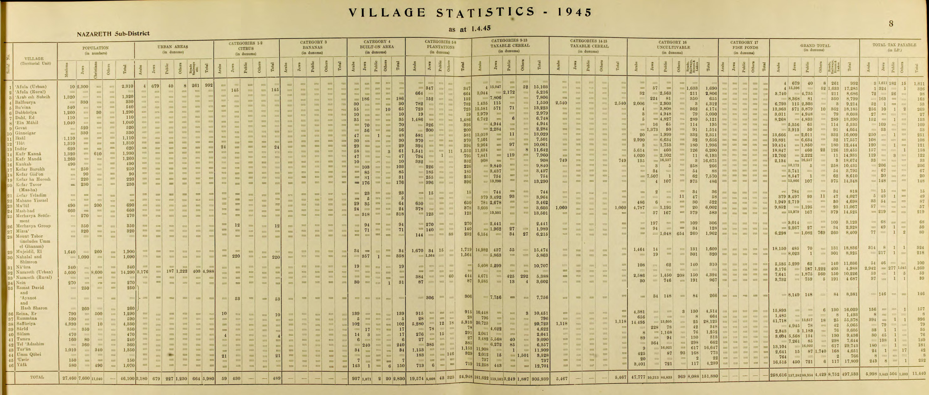
معلول Ma'lul, Maalul, Maaloul, Mahlul | |
|---|---|
 Sebuah Gereja Katolik Ma'alul pada Juli 2010 | |
| Etimologi: dari nama personal[1] | |
 Ma'alul Lokasi di Mandat Palestina | |
| Koordinat: 32°41′44″N 35°14′22″E / 32.69556°N 35.23944°E | |
| Grid Palestina | 172/233 |
| Entitas geopolitik | Mandat Palestina |
| Subdistrik | Nazareth |
| Tanggal pengosongan | 15 Juli 1948[4] |
| Luas | |
| • Total | 4,698 dunams (4,698 km2 or 1,814 sq mi) |
| Populasi (1945) | |
| • Total | 690[2][3] |
| Sebab pengosongan | Serangan militer oleh pasukan Yishuv |
| Wilayah saat ini | Migdal HaEmek, Kfar HaHoresh, Timrat,[5][6] dan sebuah pangkalan militer Israel |
Ma'alul (bahasa Arab: معلول) adalah sebuah desa yang utamanya terdiri dari Kristen Palestina. Desa tersebut dikosongkan dan dihancurkan oleh Israel pada Perang Arab-Israel 1948. Berjarak enam kilometer dari barat kota Nazareth,[7] sebagian besar penduduknya menjadi pengungsi yang diusir secara internal usai mengungsi ke Nazareth[8] dan kota tetangganya Yafa an-Naseriyye.[9]
Referensi
- ^ Palmer, 1881, p. 113
- ^ a b Government of Palestine, Department of Statistics. Village Statistics, April, 1945. Quoted in Hadawi, 1970, p. 62
- ^ Department of Statistics, 1945, p. 8
- ^ Morris, 2004, p. xvii, village #138. Also gives cause of depopulation.
- ^ Morris, 2004, p. xx, settlement #12.
- ^ Khalidi, 1992, p. 347
- ^ Ma'lul, Palestine Remembered, diakses tanggal 2008-03-31
- ^ Rabinowitz, 1997, p. 27
- ^ Nihad Bokae'e (February 2003), Palestinian Internally Displaced Persons inside Israel:Challenging the Solid Structures (PDF), Badil, diarsipkan dari asli (PDF) tanggal June 14, 2007
Daftar pustaka
- Barron, J. B., ed. (1923). Palestine: Report and General Abstracts of the Census of 1922. Government of Palestine.
- Conder, C.R.; Kitchener, H.H. (1881). The Survey of Western Palestine: Memoirs of the Topography, Orography, Hydrography, and Archaeology. Vol. 1. London: Committee of the Palestine Exploration Fund.
- Department of Statistics (1945). Village Statistics, April, 1945. Government of Palestine.
- De Haas, J. (1934). History of Palestine - The Last Two Thousand Years. Macmillan.
- Guérin, V. (1880). Description Géographique Historique et Archéologique de la Palestine (dalam bahasa French). Vol. 3: Galilee, pt. 1. Paris: L'Imprimerie Nationale. Pemeliharaan CS1: Bahasa yang tidak diketahui (link)
- Hadawi, S. (1970). Village Statistics of 1945: A Classification of Land and Area ownership in Palestine. Palestine Liberation Organization Research Center.
- Hütteroth, Wolf-Dieter; Abdulfattah, Kamal (1977). Historical Geography of Palestine, Transjordan and Southern Syria in the Late 16th Century. Erlanger Geographische Arbeiten, Sonderband 5. Erlangen, Germany: Vorstand der Fränkischen Geographischen Gesellschaft. ISBN 3-920405-41-2.
- Karmon, Y. (1960). "An Analysis of Jacotin's Map of Palestine" (PDF). Israel Exploration Journal. 10 (3, 4): 155–173, 244–253. Diarsipkan dari asli (PDF) tanggal 2019-12-22. Diakses tanggal 2020-07-26.
- Keil, C.F. (1865). Joshua, Judges, Ruth, tr. by J. Martin. Oxford University.
- Khalidi, W. (1992). All That Remains: The Palestinian Villages Occupied and Depopulated by Israel in 1948. Washington D.C.: Institute for Palestine Studies. ISBN 0-88728-224-5.
- Mills, E., ed. (1932). Census of Palestine 1931. Population of Villages, Towns and Administrative Areas. Jerusalem: Government of Palestine.
- Morris, B. (2004). The Birth of the Palestinian Refugee Problem Revisited. Cambridge University Press. ISBN 978-0-521-00967-6.
- Palmer, E. H. (1881). The Survey of Western Palestine: Arabic and English Name Lists Collected During the Survey by Lieutenants Conder and Kitchener, R. E. Transliterated and Explained by E.H. Palmer. Committee of the Palestine Exploration Fund.
- Pappé, I. (2006). The Ethnic Cleansing of Palestine. London and New York: Oneworld. ISBN 1-85168-467-0.
- Rabinowitz, Dan (1997). Overlooking Nazareth: The Ethnography of Exclusion in Galilee. Cambridge University Press. ISBN 0-521-56495-6.
- Rhode, H. (1979). Administration and Population of the Sancak of Safed in the Sixteenth Century. Columbia University. Diarsipkan dari asli tanggal 2019-04-20. Diakses tanggal 2020-07-26.
- Schumacher, G. (1888). "Population list of the Liwa of Akka". Quarterly statement - Palestine Exploration Fund. 20: 169–191.
- Schwarz, Joseph (1850). A Descriptive Geography and Brief Historical Sketch of Palestine. Translated by Isaac Leeser. Macmillan.
Pranala luar
- Welcome To Ma'lul
- Ma'alul, Zochrot
- Survey of Western Palestine, Map 5: IAA, Wikimedia commons
- Ma'lul, at Khalil Sakakini Cultural Center
- Ma3lul photos from Dr. Moslih Kanaaneh
- The Palestinian narrative has won, By Oudeh Basharat, Haaretz, 24.03.2011
Content Disclaimer
Informasi ini disarikan dari Wikipedia dan disajikan kembali untuk tujuan edukasi. Konten tersedia di bawah lisensi CC BY-SA 3.0. Kami tidak bertanggung jawab atas ketidakakuratan data yang bersumber dari kontribusi publik tersebut.
- The information displayed on this website is sourced in part or in whole from Wikipedia and has been adapted for the purpose of restating it. We strive to provide accurate and relevant information, however:
- There is no guarantee of absolute accuracy. Wikipedia is an open, collaborative project that can be edited by anyone, so information is subject to change.
- It is not intended to constitute professional advice. The content displayed is for informational and educational purposes only. For important decisions (e.g., medical, legal, or financial), please consult a professional.
- Content copyright. Wikipedia is licensed under the Creative Commons Attribution-ShareAlike License (CC BY-SA). This means that content may be reused with appropriate attribution and shared under a similar license.
- Responsible use. Any risk arising from the use of information from this website is entirely the responsibility of the user.