Provinsi Rayong
Rayong
ระยอง | |
|---|---|
 Patung Phra Aphamani dan putri duyung, karakter dari puisi epik Thailand terkenal, terletak di Ko Samet | |
 Bendera  Lambang | |
 Peta yang menandai provinsi Rayong di Thailand | |
| Negara | Thailand |
| Ibu kota | Rayong |
| Pemerintahan | |
| • Gubernur | Channa Iamsaeng (sejak Oktober 2020) |
| Luas | |
| • Total | 3.552 km2 (1,371 sq mi) |
| Peringkat | Peringkat ke-57 |
| Populasi (2018)[2] | |
| • Total | 723,316 |
| • Peringkat | Peringkat ke-35 |
| • Kepadatan | 203,6/km2 (527/sq mi) |
| • Peringkat kepadatan | Peringkat ke-14 |
| Indeks Prestasi Manusia | |
| • HAI (2017) | 0,6578 "tinggi" Peringkat ke-8 |
| Zona waktu | UTC+7 (ICT) |
| Kode pos | 21xxx |
| Kode area telepon | 038 |
| Kode ISO 3166 | TH-21 |
Provinsi Rayong (bahasa Thai: ระยอง, pengucapan [rá.jɔ̄ːŋ]) adalah satu dari 76 provinsi (changwat) di Thailand. Provinsi ini terletak di Thailand timur. Provinsi tetangganya adalah (dari barat searah jarum jam) Chonburi, dan Chanthaburi. Di selatan terdapat Teluk Thailand.[4]
Pada 2016, pendapatan per kapita di provinsi Rayong merupakan yang tertinggi daripada semua provinsi di Thailand.[5]
Simbol
Lambang provinsi ini menampilkan pulau Ko Samet. Pohon provinsialnya adalah Alexandrian laurel (Calophyllum inophyllum).
Kesehatan
Rumah sakit utama di provinsi Rayong adalah Rumah Sakit Rayong yang dioperasikan oleh Kementerian Kesehatan Masyarakat.
Tokoh terkenal dari provinsi Rayong
Galeri
-
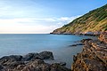
 Teluk Khao Laem Ya pada pagi hari, Taman Nasional Khao Laem Ya – Mu Ko Samet
 -
 Taman Nasional Khao Laem Ya – Mu Ko Samet
 -
 Taman Nasional Khao Laem Ya – Mu Ko Samet
 -
 Taman Nasional Khao Laem Ya – Mu Ko Samet
 -
 Taman Nasional Khao Laem Ya – Mu Ko Samet
 -
 Taman Nasional Khao Laem Ya – Mu Ko Samet
 -
 Air Terjun Khao Chamao (Khlong Nam Sai), Taman Nasional Khao Chamao–Khao Wong


Referensi
- ^ Advancing Human Development through the ASEAN Community, Thailand Human Development Report 2014, table 0:Basic Data (PDF) (Report). United Nations Development Programme (UNDP) Thailand. hlm. 134–135. ISBN 978-974-680-368-7. Diakses tanggal 17 January 2016, Data has been supplied by Land Development Department, Ministry of Agriculture and Cooperatives, at Wayback Machine. Pemeliharaan CS1: Postscript (link)[pranala nonaktif]
- ^ "ร่ยงานสถิติจำนวนประชากรและบ้านประจำปี พ.ศ.2561" [Statistics, population and house statistics for the year 2018]. Registration Office Department of the Interior, Ministry of the Interior. stat.bora.dopa.go.th (dalam bahasa Thai). 31 December 2018. Diarsipkan dari asli tanggal 2019-04-02. Diakses tanggal 20 June 2019.
- ^ Human achievement index 2017 by National Economic and Social Development Board (NESDB), pages 1-40, maps 1-9, retrieved 14 September 2019, ISBN 978-974-9769-33-1
- ^ "About Rayong". Tourism Authority of Thailand (TAT). Diakses tanggal 1 July 2019.[pranala nonaktif permanen]
- ^ "Gross Regional and Provincial Product 2016 Edition". National Economic and Social Development Board (NESDB). Diarsipkan dari asli tanggal 2018-10-16. Diakses tanggal 2 July 2019.
Pranala luar
 Panduan perjalanan Rayong di Wikiwisata
- Situs web Provinsi Diarsipkan 2021-04-16 di Wayback Machine. (bahasa Thai)
- Eastern Economic Corridor (EEC) Office
 |
Provinsi Chonburi |
| ||
| ||||
| Teluk Thailand |

12°40′32″N 101°16′42″E / 12.67556°N 101.27833°E
| Internasional | |
|---|---|
| Nasional | |
| Geografis | |
| Lain-lain | |
Content Disclaimer
Informasi ini disarikan dari Wikipedia dan disajikan kembali untuk tujuan edukasi. Konten tersedia di bawah lisensi CC BY-SA 3.0. Kami tidak bertanggung jawab atas ketidakakuratan data yang bersumber dari kontribusi publik tersebut.
- The information displayed on this website is sourced in part or in whole from Wikipedia and has been adapted for the purpose of restating it. We strive to provide accurate and relevant information, however:
- There is no guarantee of absolute accuracy. Wikipedia is an open, collaborative project that can be edited by anyone, so information is subject to change.
- It is not intended to constitute professional advice. The content displayed is for informational and educational purposes only. For important decisions (e.g., medical, legal, or financial), please consult a professional.
- Content copyright. Wikipedia is licensed under the Creative Commons Attribution-ShareAlike License (CC BY-SA). This means that content may be reused with appropriate attribution and shared under a similar license.
- Responsible use. Any risk arising from the use of information from this website is entirely the responsibility of the user.