Waldviertel

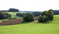
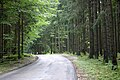
Waldviertel (Perempat Hutan) adalah sebuah kawasan yang terletak di sisi barat laut negara bagian Austria Hilir. Wilayah ini berbatasan dengan Sungai Donau di selatan, negara bagian Austria Hulu di barat daya, Ceko di barat laut dan utara, serta Manhartsberg (537 m) di timur yang merupakan titik yang memisahkan kawasan Waldviertel dengan Weinviertel.
- Waldviertel
-

-
-

-

-


Bacaan lanjut
- Birgit Zotz, Das Waldviertel - Zwischen Mystik und Klarheit. Das Image einer Region als Reiseziel. Berlin: Köster 2010, ISBN 978-3-89574-734-2
Pranala luar
 Media terkait Waldviertel di Wikimedia Commons
- Situs web resmi

- Waldviertel Wiki (Jerman)
48°31′N 15°15′E / 48.517°N 15.250°E
Artikel bertopik geografi atau tempat Austria ini adalah sebuah rintisan. Anda dapat membantu Wikipedia dengan mengembangkannya. |
| Internasional | |
|---|---|
| Nasional | |
| Lain-lain | |
Content Disclaimer
Informasi ini disarikan dari Wikipedia dan disajikan kembali untuk tujuan edukasi. Konten tersedia di bawah lisensi CC BY-SA 3.0. Kami tidak bertanggung jawab atas ketidakakuratan data yang bersumber dari kontribusi publik tersebut.
- The information displayed on this website is sourced in part or in whole from Wikipedia and has been adapted for the purpose of restating it. We strive to provide accurate and relevant information, however:
- There is no guarantee of absolute accuracy. Wikipedia is an open, collaborative project that can be edited by anyone, so information is subject to change.
- It is not intended to constitute professional advice. The content displayed is for informational and educational purposes only. For important decisions (e.g., medical, legal, or financial), please consult a professional.
- Content copyright. Wikipedia is licensed under the Creative Commons Attribution-ShareAlike License (CC BY-SA). This means that content may be reused with appropriate attribution and shared under a similar license.
- Responsible use. Any risk arising from the use of information from this website is entirely the responsibility of the user.