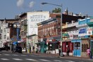
Mount Pleasant is a neighborhood in Washington, D.C., located in Northwest D.C. The neighborhood is primarily residential, with restaurants and stores centered along a commercial corridor on Mt. Pleasant Street. Mount Pleasant is known for its unique identity and multicultural landscape, home to diverse groups such as the punk rock, the Peace Corps and Hispanic Washingtonian communities.[1]
After the creation of the District of Columbia in 1791, Pleasant Plains estate became part of Washington County, but not part of the City of Washington.
In 1794 and 1796, noted Georgetown businessman Robert Peter conducted the first land surveys in the area and created maps for tracts of some of his land in Mount Pleasant for transactions with commissioners of the city.[4]
19th century
Townhomes built during the development of Mount Pleasant at the turn of the 19th and 20th centuries.
In 1861, William Selden, former Treasurer of the United States, owned 73 acres (300,000 m2) of land north of Pierce Mill Road, but having been a Confederate sympathizer, was forced was forced to sell his land at a low price and move back to Virginia. The purchaser was New England native Samuel P. Brown,[5] who built a house and also allowed the Mount Pleasant General Hospital to be constructed on his land.
After the American Civil War, Brown began selling his land in parcels. He named the area Mount Pleasant Village because it contained the land having the highest elevation within the original Pleasant Plains estate. Brown sold all of his land except for the parcel he retained around his house at 3351 Mount Pleasant Street, NW.[6]
In the 1870s, a horse-drawn streetcar began traveling between the Fourteenth and Park intersection to downtown Washington city, making this the first streetcar suburb in the District of Columbia. In 1878, Mount Pleasant merged into Washington when the city's boundaries became coterminous with those of the District.
In 1901, 16th Street NW was extended north of Florida Avenue, establishing the boundary of the neighborhood.[7] Mount Pleasant developed rapidly as a streetcar suburb after the expansion of the mechanized Washington streetcars along 16 1/2 Street (now Mount Pleasant Street) in 1903.[1][7] In 1907, developer Fulton R. Gordon purchased large sections of the neighborhood, marketing lots as "Mount Pleasant Heights" with Robert E. Heater.[8] Many houses and apartment buildings were constructed between 1900 and 1925, primarily marketed to middle- to upper middle class people.
By 1927, all homeowners in the neighborhood had signed restrictive covenants forbidding sale to African Americans. By the time of World War II, many of the row houses were converted to boarding houses, many of which were occupied by single women.[1]
Beginning in the 1960s and increasing through the 1980s, immigrants from Central America, particularly from Intipucá, El Salvador, settled in the neighborhood. The new residents developed businesses catering to Hispanic and Latino Americans along commercial portions of Mount Pleasant Street. The neighborhood also attracted former Peace Corps workers.
In 1973, the Community of Christ, a lay-led Lutheran group dedicated to social justice, bought a large building on Mount Pleasant Street and made it available rent-free to peace activists, pro-immigrant groups and musicians. In the 1980s, the group house scene flourished.[1]
The Vintage on 16th, a historic church redeveloped into luxury apartments, in 2016.
In 1987, the neighborhood was designated as a historic district.[11][12] The neighborhood was majority-minority in 1990, with African Americans making up 36% of the population, Latinos 26%, and whites 35%.
In May 1991, the Washington, D.C. riot of 1991 erupted following the shooting of Daniel Enrique Gómez by an MPD officer. The riot, which injured twelve people and destroyed several buildings in the neighborhood, was a pivotal moment in the emergence of Latino activism in DC.[13][14] In response, MPD Chief Isaac Fulwood, and city government began an outreach effort to the Latino population.[15]
21st century
The 2010 United States census, the ZIP Code 20010, which includes Mount Pleasant, was one of the "most whitened" areas of the country, with the percentage of non-Hispanic white residents increasing from 22% in 2000 to 46.7% in 2010.[16]
As of 2021, housing prices had risen significantly.[17]
Lamont Plaza sits in the heart of the Mount Pleasant neighborhood.
The population of Mount Pleasant, according to the 2010 census, was 10,459, down from 11,794 in 2000.
1990
2000
2010
white non-Hispanic
35%
35%
50%
black non-Hispanic
36%
27%
26%
Hispanic
26%
31%
25%
Asian/Pacific Islander
3.0%
6.3%
5.6%
Incomes rose during this time period.
1979
1989
1999
2010
Average family income (2010 $)
$75,980
$77,704
$90,838
$130,790
Ratio to DC average
98%
83%
89%
114%
Local institutions
Mount Pleasant Farmer's Market is held every Saturday in Lamont Plaza.
The Mount Pleasant Historic District covers a variety of types and styles of building. The western portion of the neighborhood is a largely wooded residential enclave bounded on two sides by Rock Creek Park, just east of the National Zoo. Structures in this area are primarily row houses of Neoclassical architecture with rear porches.[18] The eastern side of the neighborhood, along 16th Street NW and Mount Pleasant Street, is marked by mid-rise apartment buildings.
^"FULTON R. GORDON AND ROBERT E. HEATER ARE Extending and Beautifying the Nation's Capital.: Virginians Make a Specialty of Opening New Northwest Suburban Property". The Washington Post. February 24, 1907.
_(cropped).jpg)
.jpg)
.jpg)

.jpg)
_(4119139914).jpg)
,_10-15-24_LCCN2016849651_(cropped).jpg)
.jpg)

.jpg)

.jpg)
.jpg)
