After entering the state of New Mexico, US 70 heads southeast. Five miles (8.0 km)[2] after crossing the state line, it serves as the southern terminus for New Mexico State Road 92 (NM 92). US 70 does not have another highway junction for 21 miles (34 km),[2] where it meets New Mexico State Road 464 (NM 464) and New Mexico State Road 90 (NM 90) three miles (4.8 km)[2] north of Lordsburg. At Lordsburg, US 70 joins with Interstate 10 (I-10) eastbound, splitting off in Las Cruces, and becoming Picacho Avenue in Las Cruces. When Picacho Avenue meets Main Street, US 70 follows Main Street northbound. US 70 then crosses I-25, and has been upgraded at this point to a controlled-access highway until entering the foothills of the Organ Mountains.
US 70 at the intersection of US 285 and US 380 in Roswell.
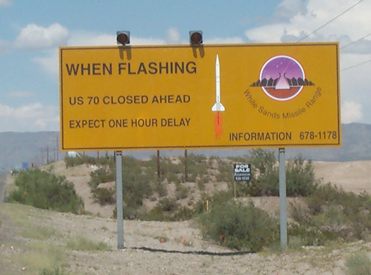
As a divided highway, US 70 then crosses the Organ Mountains via San Augustin Pass descends to the valley floor of the Tularosa Basin, and next crosses the White Sands Missile Range. Overhead missile tests can close the highway for a few hours; this generally happens once or twice a week, and typically only for an hour at a time.[3][4] The road then passes the entrance to White Sands National Park, and shortly after that passes the southern end of Holloman Air Force Base. It then turns northbound, and picks up a concurrency with US 54 upon entering Alamogordo. On the north end of Alamogordo, US 54/US 70 intersects the beginning of US 82 near La Luz. The concurrency with US 54 lasts until Tularosa, and the highway remains divided until US 70 and US 54 diverge. After splitting off to the northeast, US 70 begins an ascent into the Sacramento Mountains and enters the Lincoln National Forest. The road then runs across the Mescalero Apache Indian Reservation and near the resort town of Ruidoso. In Hondo, it begins another concurrency, this time with US 380. US 70 then bypasses Roswell to the northwest, together with US 285. US 70 then heads off to the northeast, running through Portales and Clovis before entering Texas at Texico.
History
When commissioned in 1926, ran from present day US 70 in Clovis, New Mexico through Vaughn, Willard all the way to Holbrook, Arizona. In 1932, US 70 was rerouted to El Paso, Texas, and the old routing was transferred to US 60 and US 260.[5] In 1934, the routing of US 70 was changed again, to Las Cruces; the old route was transferred to US 54.[6]
On July 12, 2021, US 70 between NASA Road and the entrance of White Sands Missile Range was closed to traffic. The night before, heavy rain from thunderstorms caused about 4 feet (1.2 m) of mud to close the 7-mile (11 km) section. The highway was reopened the next day.[7]
U.S. Route 70 Truck (US 70 Truck) runs for seven and a half miles (12.1 km) around the northwest side of Roswell. For its entire length, it is multiplexed with Roswell's Relief Route ( US 285 Truck).
^Sanderson, Dale. "End of US highway 70". Dale Sanderson. Map of US highway 70 and family, and US 412; US Highway endpoints in El Paso, TX; US Highway endpoints in Los Angeles, CA;US Highway endpoints in Holbrook, AZ. Retrieved March 27, 2017.[self-published source]


