Town in North Rhine-Westphalia, Germany
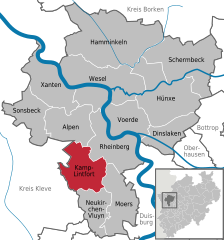
Kamp-Lintfort (German: [ˌkampˈlɪnt.fɔʁt] ⓘ) is a town in Wesel District, in North Rhine-Westphalia, Germany. It is located 8 kilometres (5 miles) north-west of Moers.
Notable people
Twin towns – sister cities
Kamp-Lintfort is twinned with:[3]
Climate
Köppen-Geiger climate classification system classifies its climate as oceanic (Cfb).[4] It lies within the Rhine-Ruhr area which is characterized by having the warmest winters in Germany.
| Climate data for Kamp-Lintfort
|
| Month
|
Jan
|
Feb
|
Mar
|
Apr
|
May
|
Jun
|
Jul
|
Aug
|
Sep
|
Oct
|
Nov
|
Dec
|
Year
|
| Mean daily maximum °C (°F)
|
4.3
(39.7)
|
5.4
(41.7)
|
9.6
(49.3)
|
14
(57)
|
18.5
(65.3)
|
21.5
(70.7)
|
22.9
(73.2)
|
22.7
(72.9)
|
19.7
(67.5)
|
14.6
(58.3)
|
8.8
(47.8)
|
5.5
(41.9)
|
14.0
(57.1)
|
| Daily mean °C (°F)
|
1.9
(35.4)
|
2.5
(36.5)
|
6.2
(43.2)
|
9.3
(48.7)
|
13.3
(55.9)
|
16.3
(61.3)
|
17.9
(64.2)
|
17.8
(64.0)
|
15.1
(59.2)
|
10.7
(51.3)
|
6.1
(43.0)
|
3.2
(37.8)
|
10.0
(50.0)
|
| Mean daily minimum °C (°F)
|
−0.5
(31.1)
|
−0.3
(31.5)
|
2.8
(37.0)
|
4.6
(40.3)
|
8.2
(46.8)
|
11.2
(52.2)
|
13
(55)
|
12.9
(55.2)
|
10.5
(50.9)
|
6.9
(44.4)
|
3.5
(38.3)
|
0.9
(33.6)
|
6.1
(43.0)
|
| Average precipitation mm (inches)
|
67
(2.6)
|
48
(1.9)
|
63
(2.5)
|
52
(2.0)
|
68
(2.7)
|
81
(3.2)
|
76
(3.0)
|
69
(2.7)
|
63
(2.5)
|
63
(2.5)
|
65
(2.6)
|
75
(3.0)
|
790
(31.2)
|
| Source: Climate-Data.org (altitude: 29m)[4]
|
References
|
|---|
|  Coat of Arms of Wesel district Coat of Arms of Wesel district |
|
|---|
| International | |
|---|
| National | |
|---|
| Geographic | |
|---|