The first section of US 195 designated as part of Washington's state highway system was codified in 1913 from Colfax to Spokane as the Inland Empire Highway and from the Idaho state line to Pullman as the Second Division of the Eastern Route of the Inland Empire Highway. The two highways were included as part of State Road 3 in 1923 and US 195 during the creation of the US Highway System on November 11, 1926. Originally, the northern terminus of the highway was at US 95 in Sandpoint, but was truncated to Spokane after US 2 was extended west from Bonners Ferry in 1946.
US 195 was cosigned with Primary State Highway 3 (PSH 3) from US 95 to Spokane and PSH 6 from Spokane to Newport from the creation of the primary and secondary state highways in 1937 until the 1964 highway renumbering. US 195 was extended south into Idaho after the relocation of US 95, designated as the North and South Highway in 1916, onto its present freeway in 1975. Bypasses of Pullman, Rosalia, and Plaza were completed during the early 1970s, converting portions of US 195 into a divided highway.
US 195 travels within Idaho for 0.577 miles (0.929 km) from an interchange with US 95 to the Washington state line, entirely north of Lewiston atop the Lewiston Hill in unincorporatedNez Perce County.[7] ITD surveys the roads under its control on a regular basis to measure the amount of traffic using the state's highways. These traffic counts are expressed in terms of annual average daily traffic (AADT), a calculation of the average daily number of vehicles on a segment of roadway. A July 2011 survey reported average daily traffic of 6,761 vehicles being served the US 95 interchange.[8]
Administratively, US 195 does not exist in Idaho. According to ITD's milepoint log, both carriageways are officially US 95 ramps into Washington state.[2]
US 195 travels 93.37 miles (150.26 km) north through the Palouse region of Eastern Washington, from the Idaho state line north to Spokane.[1] The highway serves as an important link between Pullman and Spokane as well as part of the Palouse Scenic Byway and a main north–south route in the region alongside State Route 27 (SR 27).[9][10][11] US 195 enters Washington north of Clarkston in unincorporated Whitman County and travels west to an intersection with its 0.61-mile-long (0.98 km) spur route, providing a connection to US 95 northbound towards Moscow. The highway continues northwest through farmland and the towns of Uniontown and Colton along Union Flat Creek towards Pullman. US 195 intersects SR 27, also part of the Palouse Scenic Byway,[10] and travels west of Pullman on a highway bypass of the city. The bypass travels through the termini of SR 194 and SR 270 as it leaves the Pullman area heading north towards Colfax along the South Fork Palouse River.[12] US 195 becomes Main Street within Colfax and travels through the town along a WSDOT rail line to the eastern terminus of SR 272 and SR 26.[13][14] The highway continues north along Pine Creek and the WSDOT rail line past the northern terminus of SR 271, a diamond interchange south of Rosalia,[15] before leaving the Palouse Scenic Byway at the Spokane County border.[10][11] The roadway heads north through a diamond interchange in Plaza and along Spangle Creek past the community of Spangle.[16] US 195 enters the city of Spokane as a four-lane highway along Hangman Creek and ends at a partial cloverleaf interchange with I-90, cosigned with US 2 and US 395.[7][17]
US 195 is defined by the Washington State Legislature as SR 195.[18] Every year, WSDOT conducts a series of surveys on its highways in the state to measure traffic volume. This is expressed in terms of AADT, which is a measure of traffic volume for any average day of the year. In 2012, WSDOT calculated that the busiest section of US 195 within Washington was in Hangman Valley before the I-90 interchange in Spokane, serving 19,000 vehicles, while the least busiest section was between Pullman and Colfax, serving 3,100 vehicles.[19] The entire route of US 195 is designated as a Highway of Statewide Significance by WSDOT,[20] which includes highways that connect major communities in the state of Washington.[21]
History
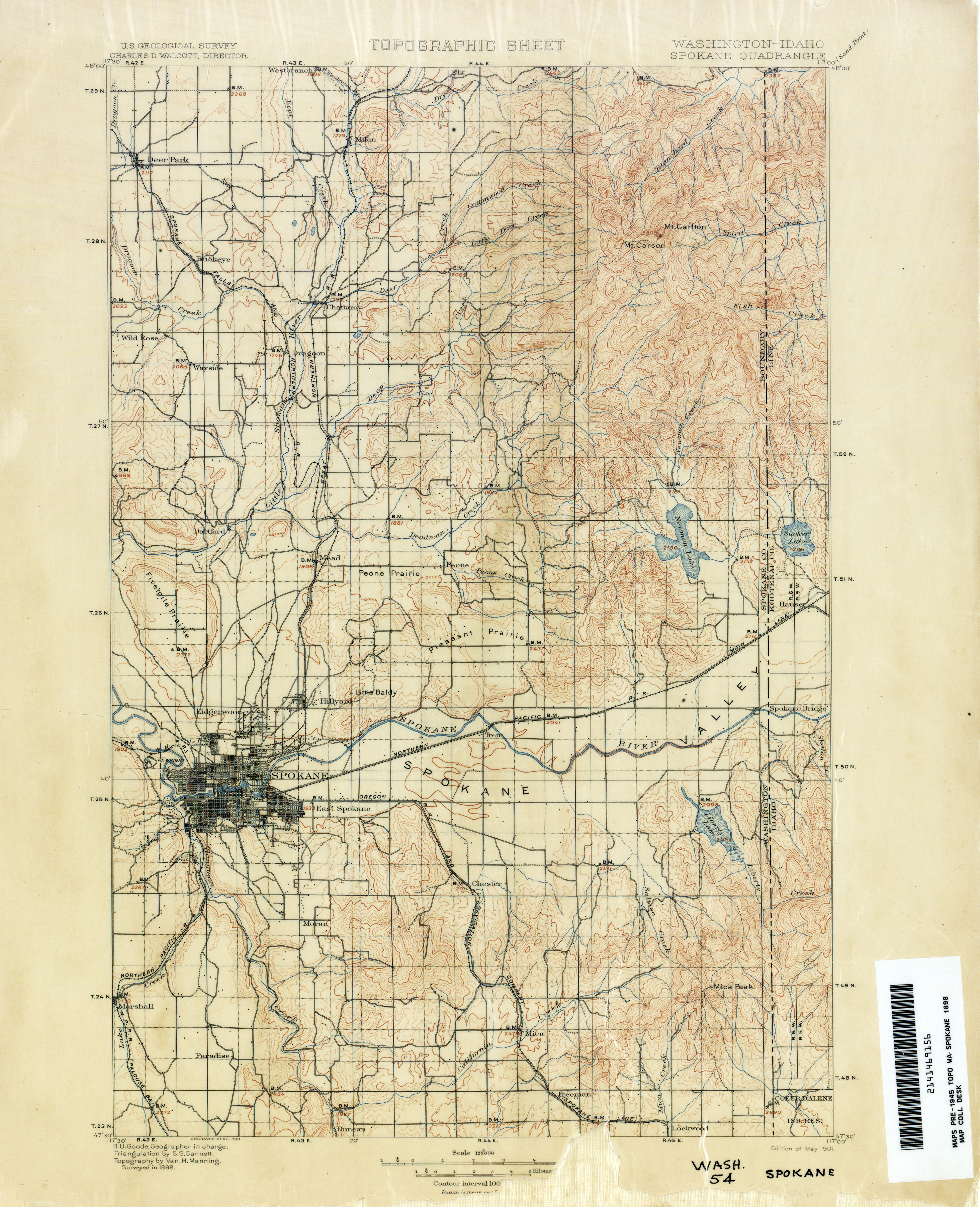
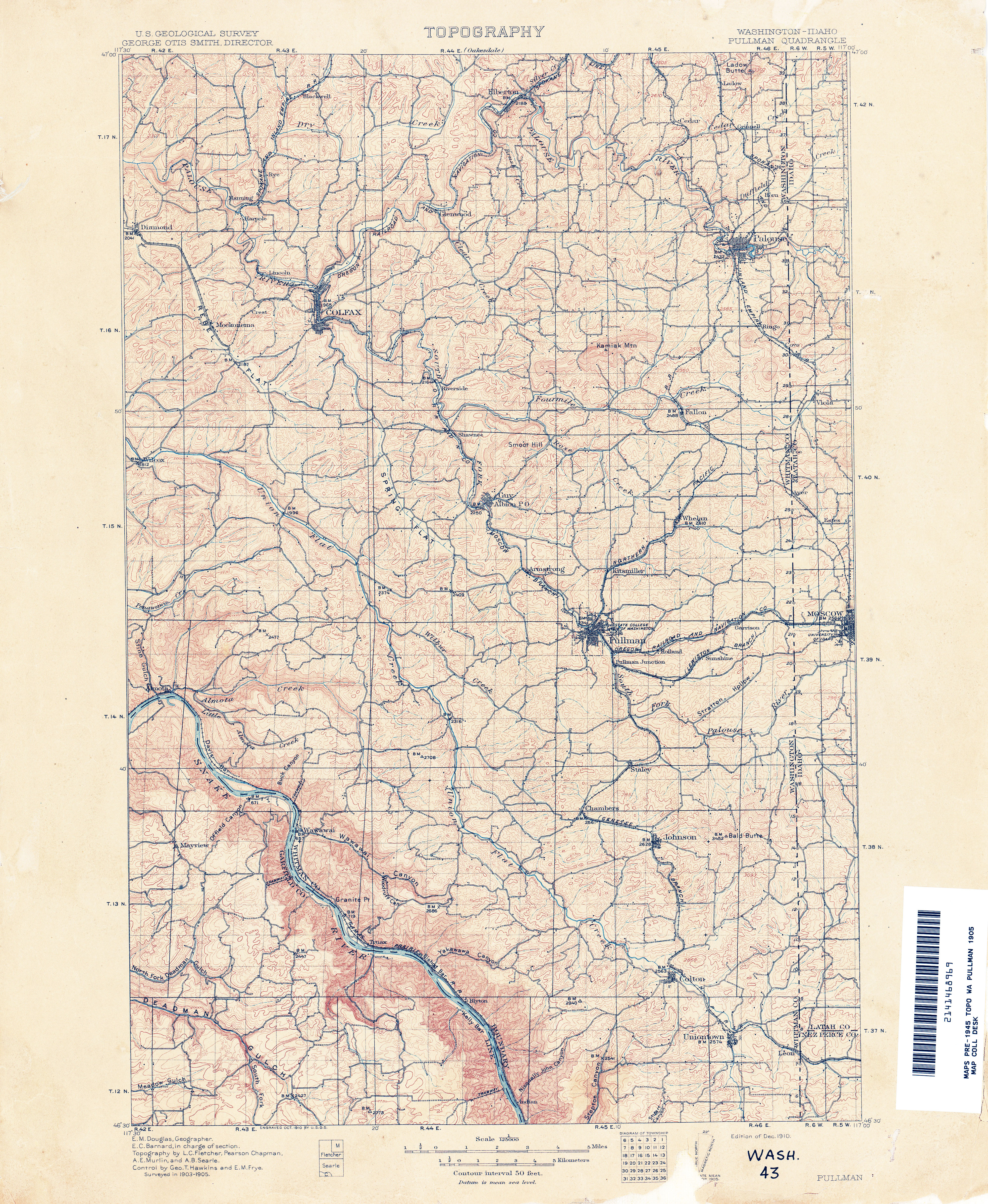
The Inland Empire Highway was originally a collection of gravel county roads that have existed since 1898 in the Spokane area and 1905 in the Pullman area.[22][23][24] These roads roughly followed an early territorial highway built in the 1870s between Colfax and Spokane.[25] The highway was added to the state highway system in 1913, traveling within the Palouse region between Colfax and Spokane. The Second Division of the Eastern Route of the Inland Empire Highway was also established in 1913, traveling northwest from Sampson Trail Y at the Idaho–Washington state line to Pullman.[26][27] The Idaho portion of US 195 became part of the North and South Highway in 1916 and was not numbered under Idaho's state highway system in 1953.[28][29] The gap in the Second Division between Pullman and Colfax was named by Whitman County as a highway of importance the following year and was not built until 1925 as part of State Road 3.[30][31]State Road 23, connecting Spokane to Newport, was designated in 1915 before it was renamed to the Pend O'Reille Highway and renumbered to State Road 6 in 1923.[32][33][34] The Inland Empire Highway was numbered as State Road 3 in 1923 and retained the designation as PSH 3 in 1937, while State Road 6 became PSH 6.[34][35]
Between 1973 and 1975, State Department of Highways completed construction of three highway bypasses around Pullman, Rosalia, and Plaza.[43][44][45] Funds that were originally intended for the canceled Bay Freeway project in Seattle were instead redirected to the bypasses earlier in the decade.[46][47] A four-lane bypass of Colfax was approved for construction in 1971, but deferred indefinitely due to a lack of funding.[48][49] The western bypass of Pullman was completed in 1974 at a cost of $1.04 million.[43]
US 95 was relocated onto its present freeway, bypassing Washington state, in 1977 and US 195 was extended south into Idaho to the new interchange with a spur route traveling towards northbound US 95.[18][50] The highway between Uniontown and Rosalia was designated as part of the Palouse Scenic Byway on December 19, 2002, as part of the Washington State Scenic and Recreational Highways program.[51][52] In 2002, WSDOT adopted a long range plan to upgrade US 195 within the Hangman Valley in Spokane to limited-access standards by constructing new interchanges at four intersections.[53] One of the interchanges, at Cheney–Spokane Road, was completed in 2014 at a cost of $9.4 million.[54] Funding for the remaining interchange projects, estimated to cost $106 million in 2002 dollars, was not allocated and WSDOT is instead considering lower-cost improvements to the intersections.[53][55] Increased traffic congestion on US 195 in Spokane lead to a development moratorium in place until capacity improvements are made to the highway.[56] The first ramp meter in the Spokane area was installed at US 195's interchange with I-90 in 2019.[57]
US 195 has a 0.54-mile-long (870 m) spur route near its southern terminus on the Washington–Idaho state line that travels east from US 195 to serve US 95 northbound atop Lewiston Hill.[1][58] The unsigned highway, also known as the Genesee Spur, was established in 1979 on the former alignment of US 95 as it passed briefly through Washington before it was moved onto its present alignment.[18][50] WSDOT included the road in its annual AADT survey in 2012 and calculated that 100 vehicles per day used the spur route.[19]ITD designates the spur route as US-95 Spur in their milepoint log.[2]
^Natzke, Stefan; Neathery, Mike & Adderly, Kevin (August 26, 2010). "What is the National Highway System?". National Highway System. Federal Highway Administration. Retrieved December 12, 2010.
^Washington State Legislature (March 12, 1913). "Chapter 65: Classifying Public Highways". Session Laws of the State of Washington (1913 ed.). Olympia, Washington: Washington State Legislature. pp. 221–222. Retrieved March 2, 2013. A highway connecting with the Sunset Highway at or in the vicinity of the city of Ellensburg; thence by way of North Yakima, Kennewick, Pasco, Walla Walla, Dayton, crossing the Snake River at either Almota or Penawawa, Colfax, Rosalia, Spokane, Deer Park, Loon Lake, Colville, to the international line at boundary, which shall be known as the Inland Empire Highway.
^Washington State Legislature (February 18, 1925). "Chapter 26". Session Laws of the State of Washington (1925 ed.). Olympia, Washington: Washington State Legislature. p. 59. Retrieved March 2, 2013. A primary state highway, to be known as State Road No. 3, or the Inland Empire Highway, is established as follows: Also from a junction at Colfax to a junction with the eastern route of the Inland Empire Highway at Pullman.
^Washington State Legislature (March 11, 1915). "Chapter 53: Public Highways Appropriation". Session Laws of the State of Washington (1915 ed.). Olympia, Washington: Washington State Legislature. p. 184. Retrieved March 2, 2013. There is hereby established a secondary highway, commencing at Spokane, Spokane county, Washington, thence northeasterly following the most feasible route through the town of Mead to Newport in Pend Oreille county, Washington, and there is hereby appropriated for survey and construction of said secondary highway.
^ abWashington State Legislature (March 19, 1923). "Chapter 185: Primary and Secondary State Highways". Session Laws of the State of Washington (1923 ed.). Olympia, Washington: Washington State Legislature. pp. 627, 629. Retrieved March 2, 2013. A primary state highway, to be known as State Road No. 3, or the Inland Empire Highway, is established as follows: Beginning at the international boundary line at Laurier in Ferry County; thence by the most feasible route in a southerly direction through Colville, Spokane, Colfax, Dayton to Walla Walla; thence in a northwesterly direction through the cities of Wallula, Pasco, Sunnyside, Yakima, Ellensburg, to a junction with the Sunset Highway at or near Virden in Kittitas County. A primary state highway, to be known as State Road No. 6 or the Pend O'Reille Highway, is established as follows: Beginning at Spokane; thence by the most feasible route in a northeasterly direction to Newport in Pend O'Reille County; thence in a northerly direction through Metaline Falls to the international boundary line.
^Washington State Legislature (March 17, 1937). "Chapter 190: Establishment of Primary State Highways". Session Laws of the State of Washington (1937 ed.). Olympia, Washington: Washington State Legislature. pp. 934–935, 937. Retrieved March 2, 2013. A primary state highway to be known as Primary State Highway No. 3, or the Inland Empire Highway, is hereby established according to description as follows: Beginning at a junction with Primary State Highway No. 2 in the vicinity east of Cle Elum, thence southeasterly by the most feasible route by way of Ellensburg, Yakima, Pasco and Wallula to Walla Walla, thence in a northerly direction by the most feasible route by way of Dayton, Dodge, Colfax, Rosalia, Spokane and Colville to the international boundary line in the vicinity of Laurier; also beginning at a junction with Primary State Highway No. 3, as herein described, in the vicinity of Dodge, thence in an easterly direction by the most feasible route by way of Pomeroy and Clarkston to the Washington-Idaho boundary line; also beginning at a junction with Primary State Highway No. 3, as herein described, in the vicinity south of Rosalia, thence in a southerly direction by the most feasible route by way of Pullman to a point of junction southeast of Uniontown, thence in an easterly direction by two most feasible routes to two points on the Washington-Idaho boundary line; also beginning at Colfax on Primary State Highway No. 3, as herein described, thence in a southeasterly direction by the most feasible route to Pullman on Primary State Highway No. 3, as herein described, thence in an easterly direction by the most feasible route to a point on the Washington-Idaho boundary line. A primary state highway to be known as Primary State Highway No. 6, or the Pend Oreille Highway, is hereby established according to description as follows: Beginning at a junction with Primary State Highway No. 3, in the vicinity north of Spokane, thence in a northerly direction by the most feasible route by way of Newport and Metaline Falls to the international boundary line; also beginning at Newport on Primary State Highway No. 6, as herein described, thence in an easterly direction to the Washington-Idaho boundary line.
AikaAika 2018Nama asalあいかLahir25 Agustus 1990 (umur 33)Tokyo, JepangTahun aktif2010-Dikenal atasFANZATinggi165 cm (5 ft 5 in) Aika (あいかcode: ja is deprecated , Aika, lahir 25 Agustus 1990) adalah seorang pemeran pornografi dan mantan model gravure asal Jepang (AV). Dia lahir di Tokyo. Debutnya sebagai aktris datang pada tahun 2011.[1] Sebelum debut, dia bekerja sebagai penata rambut. Dia ditempa serta dibina terlebih dahulu di Shibuya. Setelah it…
Biografi ini memerlukan lebih banyak catatan kaki untuk pemastian. Bantulah untuk menambahkan referensi atau sumber tepercaya. Materi kontroversial atau trivial yang sumbernya tidak memadai atau tidak bisa dipercaya harus segera dihapus, khususnya jika berpotensi memfitnah.Cari sumber: Felly Young – berita · surat kabar · buku · cendekiawan · JSTOR (Juli 2022) (Pelajari cara dan kapan saatnya untuk menghapus pesan templat ini) Yefani FilliangLahirYefani F…
Untuk kegunaan lain, lihat Karo. Artikel ini mengandung Surat Batak. Tanpa dukungan perenderan yang baik, Anda mungkin akan melihat tanda tanya, kotak, atau simbol lain. Batak KaroKalak Karoᯂᯞᯂ᯳ᯆᯗᯂ᯳ᯂᯒᯭ Djamin Ginting Suka Malem Sambat Kaban Tifatul Sembiring Anthony Sinisuka Ginting Tanta Ginting Cory Sriwaty Sebayang Lyodra Ginting Adrianus Meliala Arifin Tarigan Jumlah populasi± 1.100.000 (2010)BahasaBahasa Batak KaroAgamaKristen Protestan (57.5%) [1]Islam (21,3%…
Médaille MurchisonLa médaille Murchinson.PrésentationType Médaille, prix scientifique (d)Fondation 1873Site web (en) www.geolsoc.org.uk/About/History/Award-Winners-Since-1831/Murchison-MedalLocalisationLocalisation Royaume-Unimodifier - modifier le code - modifier Wikidata Ne doit pas être confondu avec Prix Murchison. La médaille Murchison est une récompense scientifique dans le domaine de la géologie décernée par la Geological Society of London. La médaille est nommée d'…
Episode from the Passion of Christ Peter's Denial redirects here. For other uses, see Peter's Denial (disambiguation). The Denial of Saint Peter, an oil-on-canvas painting by Gerard Seghers, dating to around 1620–25 and now held by the North Carolina Museum of Art[1] The Denial of Peter (or Peter's Denial) refers to three acts of denial of Jesus by the Apostle Peter as described in all four Gospels of the New Testament.[2] All four Canonical Gospels state that during Jesus's La…
Si ce bandeau n'est plus pertinent, retirez-le. Cliquez ici pour en savoir plus. Cet article peut contenir un travail inédit ou des déclarations non vérifiées (février 2023). Vous pouvez aider en ajoutant des références ou en supprimant le contenu inédit. Voir la page de discussion pour plus de détails. Effets du Dust Bowl : tempête de poussière dans le Texas en 1935. En écologie, une crise écologique ou crise environnementale, se définit en tant qu'érosion pérenne de la bio…
Get Well SoonAlbum studio karya Pee Wee GaskinsDirilis2022GenrePop, Indonesian Indie, Indonesian Pop, Indonesian RockDurasi26:38LabelUniversal Music GroupKronologi Pee Wee Gaskins Mixed Feeling(2019)Mixed Feeling2019 Get Well Soon(2022) Get Well Soon adalah album studio ketujuh karya Pee Wee Gaskins yang dirilis pada tahun 2022. Singel yang dirilis dari album ini adalah Vaya Con Dios, Unsteady Feeling, Summer Fling dan Fluktuasi Glukosa. Daftar lagu No.JudulDurasi1.Vaya Con Dios4:042.Unstead…
Not to be confused with Tarome, Queensland. Town in Queensland, AustraliaTaroomQueenslandView towards the north-west from Gilbert's Lookout, 2014TaroomLocation in QueenslandCoordinates25°49′36″S 149°53′48″E / 25.8266°S 149.8966°E / -25.8266; 149.8966Population869 (2016 census)[1] • Density970/km2 (2,500/sq mi)Postcode(s)4420Area0.9 km2 (0.3 sq mi)Location 380 km (236 mi) from Brisbane 302 km (188 mi) …
Sporting event delegationRepublic of the Congo at the2008 Summer OlympicsFlag of the Republic of the CongoIOC codeCGONOCComité National Olympique et Sportif Congolaisin BeijingCompetitors5 in 3 sportsFlag bearer Pamela Mouele-MboussiMedals Gold 0 Silver 0 Bronze 0 Total 0 Summer Olympics appearances (overview)1964196819721976198019841988199219962000200420082012201620202024 The Republic of the Congo sent a delegation to compete at the 2008 Summer Olympics in Beijing, China. Athletics Main a…
Ik Onkār,[1] lambang Sikh. Ik Onkar (Gurmukhi: ੴ, ਇੱਕ ਓਅੰਕਾਰ; Ikk Ōankār pengucapan Punjabi: [ɪkː oəŋkaɾ]) adalah lambang yang mewakili Satu Realitas Tertinggi[2] dan merupakan kepercayaan utama Sikhisme.[1] Ik (ਇੱਕ) berarti satu dan hanya satu, yang tidak dapat dibandingkan dengan yang lain,[3] (ਓਅੰਕਾਰ) adalah melodi ilahi universal yang selalu mengalir dan suara Tuhan eksistensial tidak tersangkut dan tidak pern…
Fußballklub 03 Pirmasens e.V.Calcio Die Macht vom Horeb Segni distintivi Uniformi di gara Casa Trasferta Colori sociali Blu, bianco Dati societari Città Pirmasens Nazione Germania Confederazione UEFA Federazione DFB Campionato Oberliga Fondazione 1903 Allenatore Peter Tretter Stadio Sportpark Husterhöhe(10 000 posti) Sito web www.fk-pirmasens.com Palmarès Si invita a seguire il modello di voce Il Fußballklub 03 Pirmasens e.V. è una squadra di calcio tedesca con sede nella città…
British artist (1919–2014) Norman CornishBerriman's Chip Van by Norman CornishBorn(1919-11-18)18 November 1919Died1 August 2014(2014-08-01) (aged 94)NationalityBritishOccupationArtistSpouseSarahChildren2 Norman Stansfield Cornish (18 November 1919 – 1 August 2014) was an English mining artist. Career Cornish was the last surviving member of the Pitman's Academy art school at the Spennymoor Settlement in County Durham in North East England.[1] A former miner,[2] he was kn…
Eurovision Song Contest 2008Country MaltaNational selectionSelection processThe GO Malta Song for Europe 2008Selection date(s)Semi-final:24 January 2008Final:26 January 2008Selected entrantMorenaSelected songVodkaSelected songwriter(s)Philip VellaGerard James BorgFinals performanceSemi-final resultFailed to qualify (14th)Malta in the Eurovision Song Contest ◄2007 • 2008 • 2009► Malta participated in the Eurovision Song Contest 2008 with the song Vodka w…
Gudja Il-GudjaDewan lokal BenderaLambang kebesaranLokasi di MaltaNegara MaltaLuas • Total2,3 km2 (9 sq mi)Populasi (2014) • Total2.997 • Kepadatan130/km2 (340/sq mi)Kode ISO 3166-2MT-11Situs webhttp://www.gudja.org.mt/ Gudja adalah salah satu dewan lokal di Malta. Menurut sensus 2014, Gudja memiliki luas 2,3 kilometer persegi dan populasi 2.997 jiwa. Kode ISO 3166-2 daerah ini adalah MT-11. Referensi City Population: Malta Diarsip…
Nick FuentesFuentes pada tahun 2022LahirNicholas Joseph Fuentes18 Agustus 1998 (umur 25)Illinois, Amerika Serikat[1]KebangsaanAmerika SerikatPendidikanLyons Township High SchoolPekerjaanPodcasterAktivisTahun aktif2016–kiniDikenal atasMantan YouTuberGroypersPartai politikPartai RepublikGerakan politikPolitik sayap kanan jauh[2][3][4][5] Nasionalisme kulit putih[6][7]Paleokonservatisme Nicholas Joseph Fuentes (lahir 18 Agustus 199…
Upcoming film by Chris Sanders For the 2016 book of the same name, see Peter Brown (illustrator). The Wild RobotTeaser posterDirected byChris SandersWritten byChris SandersBased onThe Wild Robotby Peter BrownProduced byJeff HermannStarring Lupita Nyong'o Pedro Pascal Kit Connor Bill Nighy Stephanie Hsu Mark Hamill Catherine O'Hara Matt Berry Ving Rhames Edited byMary BleeMusic by Kris Bowers ProductioncompanyDreamWorks AnimationDistributed byUniversal PicturesRelease date September 27, …
East Timor between 1999 and 2002 East TimorTimor-Leste (Portuguese)Timor Lorosa'e (Tetum) تيمور الشرقية (Arabic)东帝汶 (Chinese)Timor oriental (French)Восточный Тимор (Russian)Timor oriental (Spanish)1999–2002 Flag Coat of arms Location of East Timor at the end of the Indonesian archipelago.StatusUnited Nations protectorateCapitalDiliCommon languagesTetumPortugueseIndonesianEnglishTransitionalAdministrator • 1999–2002 Sérgio Vieira de Mello…


.svg)


