|
DD postcode area
Postcode area within the United Kingdom
KML is from Wikidata Postcode area in United Kingdom
The DD postcode area, also known as the Dundee postcode area,[2] is a group of eleven postcode districts in eastern Scotland, within nine post towns. These cover Dundee and Angus (including Forfar, Arbroath, Brechin, Carnoustie, Kirriemuir and Montrose), plus part of north-east Fife (including Newport-on-Tay and Tayport) and small parts of Perth and Kinross and Aberdeenshire.
Coverage
The approximate coverage of the postcode districts:
| Postcode district
|
Post town
|
Coverage
|
Local authority area(s)
|
| DD1
|
DUNDEE
|
Most of the city centre, the University and the Riverside
|
Dundee
|
| DD2
|
DUNDEE
|
The West of the city including Lochee, Blackness, Ninewells, Menzieshill, Charleston, Balgay, Ardler and Logie
|
Dundee, Perth and Kinross
|
| DD3
|
DUNDEE
|
The northwest of the city including St Marys, Downfield and Kirkton, and the inner city areas of Strathmartine, Coldside and the Hilltown
|
Dundee, Angus
|
| DD4
|
DUNDEE
|
The inner city area of Stobswell and Craigie, and the northeast of the city including Pitkerro, Douglas, Fintry and Whitfield
|
Dundee, Angus
|
| DD5
|
DUNDEE
|
The east of the city including Broughty Ferry, Barnhill and Monifieth
|
Dundee, Angus
|
| DD6
|
NEWPORT-ON-TAY
|
Newport-on-Tay, Wormit, Balmerino, Gauldry
|
Fife
|
| TAYPORT
|
Tayport
|
| DD7
|
CARNOUSTIE
|
Carnoustie
|
Angus
|
| DD8
|
FORFAR
|
Forfar, Glamis, Letham
|
Angus
|
| KIRRIEMUIR
|
Kirriemuir
|
| DD9
|
BRECHIN
|
Brechin, Edzell
|
Angus
|
| DD10
|
MONTROSE
|
Montrose, St Cyrus, Inverbervie, Hillside, Gourdon
|
Angus, Aberdeenshire
|
| DD11
|
ARBROATH
|
Arbroath, Friockheim
|
Angus
|
Map
KML is from Wikidata
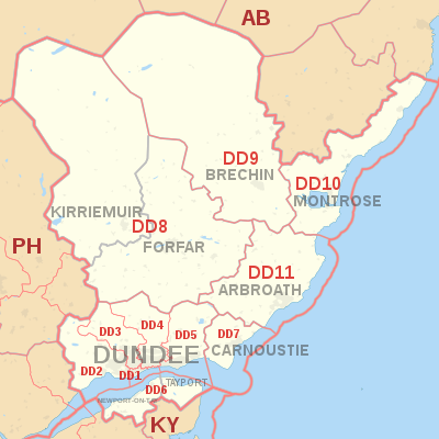 DD postcode area map, showing postcode districts in red and post towns in grey text, with links to nearby AB, KY and PH postcode areas. DD postcode area map, showing postcode districts in red and post towns in grey text, with links to nearby AB, KY and PH postcode areas.
See also
References
External links
|
|---|
| | Crown dependencies | |
|---|
| Overseas territories | |
|---|
| Non-geographic | |
|---|
|
|
|


