|
WN postcode area
Postcode area within the United Kingdom
KML is from Wikidata Postcode area in United Kingdom
The WN postcode area, also known as the Wigan postcode area,[2] is a group of eight postcode districts in North West England, within three post towns. These cover most of the Metropolitan Borough of Wigan in Greater Manchester (including Wigan itself and Leigh), plus small parts of West Lancashire (including Skelmersdale) and the Metropolitan Borough of St Helens in Merseyside.
Coverage
The approximate coverage of the postcode districts:
| Postcode district
|
Post town
|
Coverage
|
Local authority area(s)
|
| WN1
|
WIGAN
|
Haigh, Ince, Swinley, Wigan
|
Wigan
|
| WN2
|
WIGAN
|
Abram, Aspull, Bamfurlong, Bickershaw, Haigh, Hindley, Hindley Green, Ince, Platt Bridge
|
Wigan
|
| WN3
|
WIGAN
|
Goose Green, Ince, Winstanley, Worsley Mesnes, Hawkley Hall
|
Wigan
|
| WN4
|
WIGAN
|
Ashton-in-Makerfield, Garswood
|
Wigan, St Helens
|
| WN5
|
WIGAN
|
Billinge, Newtown, Higher End, Orrell, Pemberton, Winstanley, Worsley Hall, Marsh Green.
|
Wigan, St Helens
|
| WN6
|
WIGAN
|
Appley Bridge, Beech Hill, Shevington, Springfield, Standish, Wrightington
|
Wigan, West Lancashire
|
| WN7
|
LEIGH
|
Leigh, Hope Carr, Landside, Low Common, Bedford, Westleigh, Pennington, Higher Folds
|
Wigan
|
| WN8
|
WIGAN
|
Dalton, Newburgh, Parbold
|
West Lancashire
|
| SKELMERSDALE
|
Chapel House, Holland Moor, Roby Mill, Skelmersdale, Up Holland
|
Map
KML is from Wikidata
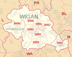 WN postcode area map, showing postcode districts in red and post towns in grey text, with links to nearby BL, L, M, PR and WA postcode areas. WN postcode area map, showing postcode districts in red and post towns in grey text, with links to nearby BL, L, M, PR and WA postcode areas.
See also
References
External links
|
|---|
| | Crown dependencies | |
|---|
| Overseas territories | |
|---|
| Non-geographic | |
|---|
|
|
|

