Kafr 'Ana' (Arabic: كفرعانة, also: Kafr Ana) was a Palestinian town located 11 kilometers (6.8 mi) east of Jaffa, built on the ancient site of Ono. In 1945, the town had an estimated population of 2,800 Arabs and 220 Jews. Prior to being captured by the pre-state Jewish forces of the Alexandroni Brigade in April of 1948 (weeks before the start of the 1948 Arab–Israeli War) and facing conflict, the inhabitants fled.[7]
Today, the old village site lies within the confines of the modern Israeli city of Or Yehuda.
Jewish classical writings mention the city as being formerly enclosed by a wall.[10][11] Kafr 'Ana was known as Onous in the Byzantine era,[12] and ceramics from that era have been found here.[13] Kafr 'Ana actually represents a Byzantine-period expansion of a nearby and much older site –– Kafr Juna, believed to be the ancient Ono.[14]
In 1596, Kafr 'Ana appeared in the census located in the Nahiya of Ramla, part of Gaza Sanjak. The population was 11 households, all Muslim. They paid a fixed tax-rate of 25% on agricultural products, including wheat, barley, summer crops, vineyards, fruit trees, sesame, goats and beehives; in addition to occasional revenues, a total of 26,800 akçe. All of the revenue went to a waqf.[17]
In the 18th century, Kafr 'Ana absorbed the population of the village of Subtara, abandoned under nomadic pressures, which was the largest village in the neighbourhood.[18]
During
In 1838, Kefr 'Âna was noted as a Muslim village in the Lydda District.[19]
French explorer Victor Guérin visited the village in 1863 and found it to have 500 inhabitants.[20] He further noted that "near the village are two shallow basins hollowed in rock, not built up, which receive the winter rains. Several wells are here as well, which permit the gardens to be irrigated. By the side of one of these wells I observed trunks of columns which seemed ancient."[21]
An Ottoman village list of about 1870 counted 156 houses and a population of 499, though the population count included only men.[22][23]
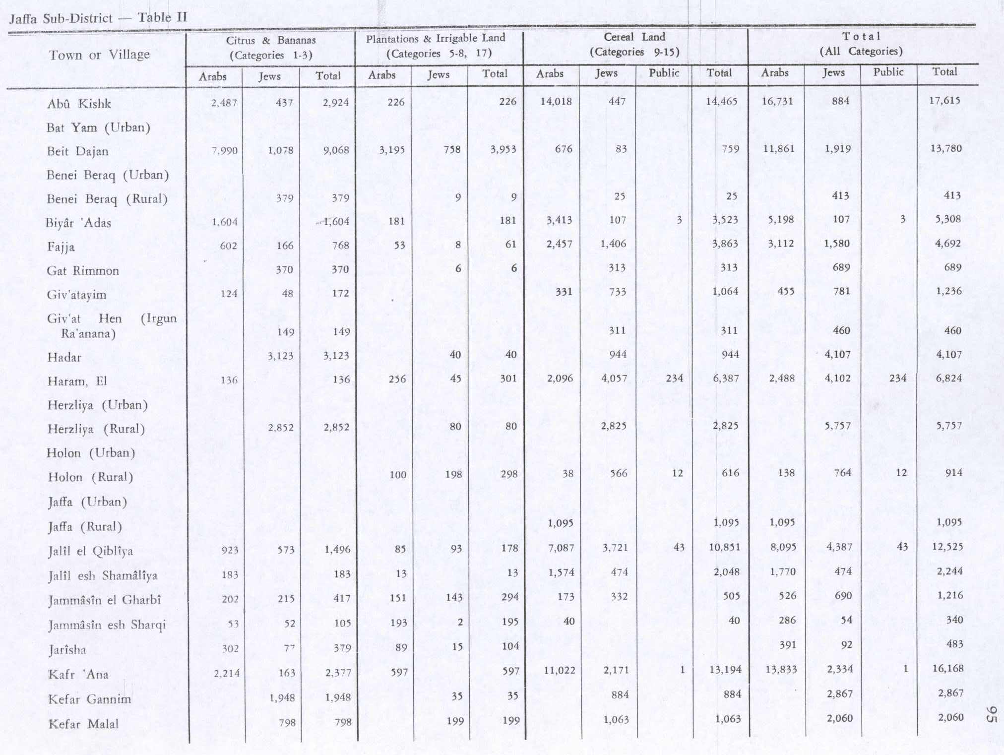
The villagers grew crops and raised poultry and bees. In the 1944/45 statistics a total 2,214 dunums were used for growing citrus and bananas, while 11,022 dunums of village land were used for cereals. 597 dunums were irrigated or used for orchards,[12][27] while 90 dunams were classified as built-up areas.[28]
The inhabitants and militiamen of Kafr' Ana fled in the weeks leading up to the 1948 Arab–Israeli War, during the Haganah's offensive Mivtza Hametz (Operation Hametz) 28–30 April 1948. This operation was held against a group of villages east of Jaffa, including Kafr 'Ana. According to the preparatory orders, the objective was for "opening the way [for Jewish forces] to Lydda". The initial order made no explicit mention of the prospective treatment of the villagers and the order spoke of "cleansing the area" [tihur hashetah].[29] However, the final operational order stated: "Civilian inhabitants of places conquered would be permitted to leave after they are searched for weapons." During the operation, "the inhabitants and militiamen [sic] panicked and fled with the approach of the Haganah columns or as the rounds began to fall".[30]
On 23 September 1948 General Avner named Kafr 'Ana as a suitable village for resettlement for new Jewish immigrants ("olim") to Israel.[31] Today, the modern Israeli city, Or Yehuda, is built upon the lands formerly belonging to Kafr 'Ana and Saqiya village and Kheiriya village.[32]Or Yehuda was founded in 1950, on village land, south of the village site.[5]
In 1992 the village site was described: "Part of the site is a vacant lot. On other parts, olive trees grow, along with cypress and eucalyptus trees that have been planted by the residents of the Israeli settlements. No traces of the old houses can be discerned. Apartment buildings and a small park have been built on the surrounding land."[5]
Culture
A woman's thob (loose fitting robe with sleeves), from Kafr Ana, from the 1930s, is in the Museum of International Folk Art (MOIFA) collection at Santa Fe, United States. The dress is of white commercial cotton and the embroidery is multicolored cotton, mainly in red and blue. The qabbeh (the square chest panel) is not a separate panel, but instead executed directly on the dress. The embroidery on the skirt and sleeves is also done directly on the dress. There is some machine embroidery, but most is by hand. The dress has an uncommon round neckline, which was an innovation and was only used here and in the village of Salama, near Jaffa.[33]
^HGS\Operations to Alexandroni, etc., "Orders for Operation "Hametz", 26 April 1948. IDFA 6647\49\\15. Cited in Morris, 2004, pp. 217, 286
^Christie, W.M. (1925). "The Jamnia Period in Jewish History". The Journal of Theological Studies. 26 (104): 348. JSTOR23950037.;Maisler (Mazar), Benjamin (1932). "The Method of Transcribing Geographical and Personal Names". Lĕšonénu: A Journal for the Study of the Hebrew Language and Cognate Subjects: 19. JSTOR24384308.; Shmuel Klein, Eretz Yehudah (Heb. ארץ יהודה : מימי העליה מבבל עד חתימת התלמוד), Tel-Aviv 1939, s.v. אונו (Ono)
^Hütteroth and Abdulfattah, 1977, p. 156. Note that Khalidi, 1992, p. 247 here mixed this Kafr 'Ana up with a Kafr Ana in the Jerusalem district; Hütteroth and Abdulfattah, 1977, p. 119
^Government of Palestine, Department of Statistics. Village Statistics, April, 1945. Quoted in Hadawi, 1970, p. 95
^Government of Palestine, Department of Statistics. Village Statistics, April, 1945. Quoted in Hadawi, 1970, p. 145
^HGS\Operations to Alexandroni, etc., "Orders for Operation "Hametz", 26 April 1948. IDFA 6647\49\\15. Cited in Morris, 2004, pp. 217, 286
^Operation Hametz HQ to Givati, etc., 27 April 1948, 14:00 hours, IDFA 67\51\\677. See also Alexandroni to battalions, 27 April 1948, IDFA 922\75\\949. Cited in Morris, 2004, pp. 217, 286
^Protocol of Meeting of Military Government Committee, 23 September 1948, ISA FM 2564\11. Cited in Morris, 2004, pp. 394, 413
^Khalidi, 1992, pp. 247-248; Carta's Official Guide to Israel, Jerusalem 1983, p. 358.

.jpg)
.jpg)
.jpg)
.jpg)


