Llanos Basin

Llanos Basin
Cuenca Llanos
The Llanos Basin in Puerto López, Meta
Coordinates05°24′00″N 71°40′00″W / 5.40000°N 71.66667°W / 5.40000; -71.66667
EtymologyLlanos Orientales
Spanish: "eastern plains"
RegionOrinoquía
Country Colombia
State(s)Arauca, Boyacá, Casanare, Cundinamarca, Guainía, Guaviare, Meta, Norte de Santander
CitiesVillavicencio, Yopal
Characteristics
On/OffshoreOnshore
BoundariesColombia-Venezuela border (N), Guiana Shield (E), Vaupés Arch (S), Serranía de la Macarena (SW), Eastern Ranges (W)
Part ofAndean foreland basins
Area96,000 km2 (37,000 sq mi)
Hydrology
River(s)Orinoco watershed
Main rivers: Arauca, Meta, Guaviare, Vichada
Geology
Basin typeForeland on rift basin[note 1]
PlateSouth American[note 3]
OrogenyBreak-up of Pangea (Mesozoic)
Andean (Cenozoic)
AgePaleozoic or Jurassic[note 2]
to Holocene
StratigraphyStratigraphy
FaultsEastern (W, bounding), Chichimene & Meta
Field(s)Rubiales, Caño Limón, many more

The Llanos Basin (Spanish: Cuenca Llanos) or Eastern Llanos Basin (Spanish: Cuenca de los Llanos Orientales) is a major sedimentary basin of 96,000 square kilometres (37,000 sq mi) in northeastern Colombia. The onshore foreland on Mesozoic rift basin covers the departments of Arauca, Casanare and Meta and parts of eastern Boyacá and Cundinamarca, western Guainía, northern Guaviare and southeasternmost Norte de Santander. The northern boundary is formed by the border with Venezuela, where the basin grades into the Barinas-Apure Basin.

Description

The northeastern part of Colombia is characterized by its wavy plains, called Llanos Orientales, as part of the bigger Llanos that extend into Venezuela. The landscape is similar to a savanna and is poor in trees. It is located between the Eastern Ranges of the Colombian Andes in the west, the Vaupés Arch in the south and the Guiana Shield in the east.[1]

Geologically, the Llanos Basin underlies this typical landscape of the Llanos. An area where transport occurs mostly by small boats along the many rivers and the "buses of the Llanos", the Douglas DC-3 planes. The basin covers an area of 96,000 square kilometres (37,000 sq mi) and contains a stratigraphic column from the Paleozoic to recent.[2] Several of the formations in the basins are source rocks (Gachetá, Los Cuervos, Carbonera C8), reservoir rocks (Mirador, Barco, Guadalupe and the uneven numbered members of Carbonera). Seals are formed by the shaly intervals (even numbered) of the Carbonera Formation, Los Cuervos, and León.[3]

The basin is the main petroleum producing basin of Colombia, with four of the nations biggest oil fields located in the Llanos Basin. Major fields are Rubiales, Colombia's biggest and most recent giant discovery sealed by a complex of hydrodynamic processes, and Caño Limón, at the border with Venezuela.

Major concerns in the basin for the production of petroleum are biodegradation, hydrocarbon migration, fault seal capacity and water flow.

Hydrography

Rivers of the Llanos Basin
Ariarí River

The Llanos Basin is crossed by numerous rivers, all belonging to the Orinoco watershed. From north to south:

Flora and fauna

Fauna

Map of national parks in Orinoquía region

Among other species, Lynch's swamp frog (Pseudopaludicola llanera) is endemic to the Llanos, with the species epithet referring to the plains.[4] Also the whip scorpion Mastigoproctus colombianus is reported from the Llanos Basin.[5]

Geodynamic situation

Plate tectonic situation of northwestern South America.
Nazca Plate has been subdivided into Coiba and Malpelo Plates
Coiba & Malpelo Plates

The country of Colombia spreads out over six tectonic plates, clockwise from north:

  1. Caribbean Plate
  2. North Andes Plate
  3. South American Plate
  4. Malpelo Plate
  5. Coiba Plate
  6. Panama Plate

The Llanos Basin is situated entirely on the South American Plate, bordering the North Andean Block or North Andean microplate in the west. The basin is one of three Colombian basins on the South American Plate, to the south the Caguán-Putumayo Basin and to the southeast the Vaupés-Amazonas Basin. The northern boundary of the Llanos Basin is formed by the Colombia-Venezuela border where the basin grades into the Barinas-Apure Basin on the Venezuelan side. The Catatumbo Basin, representing the Colombian portion of the larger Maracaibo Basin borders the Llanos Basin in the northwest and the western boundary is formed by the foothills (Piedemonte) of the Eastern Cordillera Basin, the sedimentary basin covering the Eastern Ranges of the Colombian Andes.

Tectonics

The basin is bound to the west by the Eastern Frontal Fault System, a 921.4 kilometres (572.5 mi) long fault system connecting the North Andes and South American Plates and thus the Eastern Cordillera Basin and the Llanos Basin. The fault system has an average strike of 042.1±19, but this orientation varies greatly along its course. The 1827, 1834, 1917, 1967, 1995, and 2008 earthquakes were all caused by fault movement as part of the system.[6]

Basin history

The tectonic history of the Llanos Basin, a foreland basin formed on top of Mesozoic rift basins, Paleozoic metasediments and Precambrian basement underlain by continental crust, goes back to the Early Jurassic.

The Andean orogeny, represented by the tectonic uplift of the Colombian Eastern Ranges and its northern extension, the Serranía del Perijá, caused tilting and uplift in the Llanos Basin. During the Andean orogenic phase, the paleotemperatures in the basin dropped considerably; in the Baja Guajira area from 115 °C (239 °F) in the Early Miocene to 70 °C (158 °F) in the Late Miocene.[7] In the Late Miocene to Pliocene, the major faults to the southwest of the Cocinetas Basin, the Oca and Bucaramanga-Santa Marta Faults were tectonically active.[8]

Basement

The Cerros de Mavecure in Guainía are a remnant of the Proterozoic basement underlying the Llanos Basin
The Serranía de Chiribiquete in Guaviare

The stratigraphy of the Llanos Basin ranges, depending on the definition from either Jurassic or Paleozoic to recent. The basement is formed by the westernmost extensions of the Guiana Shield. Remnants of these Precambrian formations are found as inselbergs in the far east of Colombia (Cerros de Mavecure), in the Serranía de la Macarena to the southwest of the basin and in the tepuis of the Serranía de Chiribiquete to the southeast.

The Proterozoic crystalline rocks are overlain by metamorphosed sedimentary and igneous rocks ranging in age from Cambrian to Devonian. Younger and contemporaneous Paleozoic deposits are only found in the subsurface and in regional correlative units as the Floresta and Cuche Formations of the Altiplano Cundiboyacense to the direct northwest and the Río Cachirí Group of the Cesar-Ranchería Basin farther northwest of the Llanos Basin.

The units found in the Llanos Basin pertain to the Farallones Group and comprise the Valle del Guatiquía Red Beds, Pipiral Shale and the Gutiérrez Sandstone.[9]

Stratigraphy

Stratigraphy of the Llanos Basin and surrounding provinces
Ma Age Paleomap Regional events Catatumbo Cordillera proximal Llanos distal Llanos Putumayo VSM Environments Maximum thickness Petroleum geology Notes
0.01 Holocene
Holocene volcanism
Seismic activity
alluvium Overburden
1 Pleistocene
Pleistocene volcanism
Andean orogeny 3
Glaciations
Guayabo Soatá
Sabana
Necesidad Guayabo Gigante
Alluvial to fluvial (Guayabo) 550 m (1,800 ft)
(Guayabo)
[10][11][12][13]
2.6 Pliocene
Pliocene volcanism
Andean orogeny 3
GABI
Subachoque
5.3 Messinian Andean orogeny 3
Foreland
Marichuela Caimán Honda [12][14]
13.5 Langhian Regional flooding León hiatus Caja León Lacustrine (León) 400 m (1,300 ft)
(León)
Seal [13][15]
16.2 Burdigalian Miocene inundations
Andean orogeny 2
C1 Carbonera C1 Ospina Proximal fluvio-deltaic (C1) 850 m (2,790 ft)
(Carbonera)
Reservoir [14][13]
17.3 C2 Carbonera C2 Distal lacustrine-deltaic (C2) Seal
19 C3 Carbonera C3 Proximal fluvio-deltaic (C3) Reservoir
21 Early Miocene Pebas wetlands C4 Carbonera C4 Barzalosa Distal fluvio-deltaic (C4) Seal
23 Late Oligocene
Andean orogeny 1
Foredeep
C5 Carbonera C5 Orito Proximal fluvio-deltaic (C5) Reservoir [11][14]
25 C6 Carbonera C6 Distal fluvio-lacustrine (C6) Seal
28 Early Oligocene C7 C7 Pepino Gualanday Proximal deltaic-marine (C7) Reservoir [11][14][16]
32 Oligo-Eocene C8 Usme C8 onlap Marine-deltaic (C8) Seal
Source
[16]
35 Late Eocene
Mirador Mirador Coastal (Mirador) 240 m (790 ft)
(Mirador)
Reservoir [13][17]
40 Middle Eocene Regadera hiatus
45
50 Early Eocene
Socha Los Cuervos Deltaic (Los Cuervos) 260 m (850 ft)
(Los Cuervos)
Seal
Source
[13][17]
55 Late Paleocene PETM
2000 ppm CO2
Los Cuervos Bogotá Gualanday
60 Early Paleocene SALMA Barco Guaduas Barco Rumiyaco Fluvial (Barco) 225 m (738 ft)
(Barco)
Reservoir [10][11][14][13][18]
65 Maastrichtian
KT extinction Catatumbo Guadalupe Monserrate Deltaic-fluvial (Guadalupe) 750 m (2,460 ft)
(Guadalupe)
Reservoir [10][13]
72 Campanian End of rifting Colón-Mito Juan [13][19]
83 Santonian Villeta/Güagüaquí
86 Coniacian
89 Turonian Cenomanian-Turonian anoxic event La Luna Chipaque Gachetá hiatus Restricted marine (all) 500 m (1,600 ft)
(Gachetá)
Source [10][13][20]
93 Cenomanian
Rift 2
100 Albian Une Une Caballos Deltaic (Une) 500 m (1,600 ft)
(Une)
Reservoir [14][20]
113 Aptian
Capacho Fómeque Motema Yaví Open marine (Fómeque) 800 m (2,600 ft)
(Fómeque)
Source (Fóm) [11][13][21]
125 Barremian High biodiversity Aguardiente Paja Shallow to open marine (Paja) 940 m (3,080 ft)
(Paja)
Reservoir [10]
129 Hauterivian
Rift 1 Tibú-
Mercedes
Las Juntas hiatus Deltaic (Las Juntas) 910 m (2,990 ft)
(Las Juntas)
Reservoir (LJun) [10]
133 Valanginian Río Negro Cáqueza
Macanal
Rosablanca
Restricted marine (Macanal) 2,935 m (9,629 ft)
(Macanal)
Source (Mac) [11][22]
140 Berriasian Girón
145 Tithonian Break-up of Pangea Jordán Arcabuco Buenavista
Saldaña Alluvial, fluvial (Buenavista) 110 m (360 ft)
(Buenavista)
"Jurassic" [14][23]
150 Early-Mid Jurassic
Passive margin 2 La Quinta
Noreán
hiatus Coastal tuff (La Quinta) 100 m (330 ft)
(La Quinta)
[24]
201 Late Triassic
Mucuchachi Payandé [14]
235 Early Triassic
Pangea hiatus "Paleozoic"
250 Permian
300 Late Carboniferous
Famatinian orogeny Cerro Neiva
()
[25]
340 Early Carboniferous Fossil fish
Romer's gap
Cuche
(355-385)
Farallones
()
Deltaic, estuarine (Cuche) 900 m (3,000 ft)
(Cuche)
360 Late Devonian
Passive margin 1 Río Cachirí
(360-419)
Ambicá
()
Alluvial-fluvial-reef (Farallones) 2,400 m (7,900 ft)
(Farallones)
[22][26][27][28][29]
390 Early Devonian
High biodiversity Floresta
(387-400)
Shallow marine (Floresta) 600 m (2,000 ft)
(Floresta)
410 Late Silurian Silurian mystery
425 Early Silurian hiatus
440 Late Ordovician
Rich fauna in Bolivia San Pedro
(450-490)
Duda
()
470 Early Ordovician First fossils Busbanzá
(>470±22)
Guape
()
Río Nevado
()
[30][31][32]
488 Late Cambrian
Regional intrusions Chicamocha
(490-515)
Quetame
()
Ariarí
()
SJ del Guaviare
(490-590)
San Isidro
()
[33][34]
515 Early Cambrian Cambrian explosion [32][35]
542 Ediacaran
Break-up of Rodinia pre-Quetame post-Parguaza El Barro
()
Yellow: allochthonous basement
(Chibcha Terrane)
Green: autochthonous basement
(Río Negro-Juruena Province)
Basement [36][37]
600 Neoproterozoic Cariri Velhos orogeny Bucaramanga
(600-1400)
pre-Guaviare [33]
800
Snowball Earth [38]
1000 Mesoproterozoic
Sunsás orogeny Ariarí
(1000)
La Urraca
(1030-1100)
[39][40][41][42]
1300 Rondônia-Juruá orogeny pre-Ariarí Parguaza
(1300-1400)
Garzón
(1180-1550)
[43]
1400
pre-Bucaramanga [44]
1600 Paleoproterozoic Maimachi
(1500-1700)
pre-Garzón [45]
1800
Tapajós orogeny Mitú
(1800)
[43][45]
1950 Transamazonic orogeny pre-Mitú [43]
2200 Columbia
2530 Archean
Carajas-Imataca orogeny [43]
3100 Kenorland
Sources
Legend
  • group
  • important formation
  • fossiliferous formation
  • minor formation
  • (age in Ma)
  • proximal Llanos (Medina)[note 4]
  • distal Llanos (Saltarin 1A well)[note 5]


Paleozoic

Cambro-Ordovician
Pre-Devonian
Devonian

Jurassic

Petroleum geology

The Llanos Basin is the most prolific hydrocarbon basin of Colombia, hosting well-known petroleum deposits as Caño Limón, Rubiales and other fields. Nine of the twenty most producing oil fields of Colombia are situated in the Llanos Basin.

Fields

Based on data released in March 2018, Colombia is the 21st oil producer in the world. Daily production dropped in 2017 to 854.121 thousand barrels per day (135.7944×10^3 m3/d).[50] In 2016, twenty oilfields produced 66% of all oil of Colombia, listed below in bold.[51] The total proven reserves of Colombia were 1,665.489 million barrels (264.7916×10^6 m3) in 2016.[52]

Major oil fields in the Llanos Basin are:[53]

Major oil and gas fields of the Llanos Basin
Name Map Location Operator Reservoirs Reserves
Production (2016)
Notes
Rubiales
Puerto Gaitán
Meta
Ecopetrol Carbonera 7 4,380 million bbl (696 million m3)
132.000 kbbl/d (20.9863×10^3 m3/d)
Castilla
Castilla la Nueva
Meta
Ecopetrol Mirador
Gachetá
Une
452 million bbl (71.9 million m3)
121.363 kbbl/d (19.2952×10^3 m3/d)
[54][55]
Chichimene
Acacias
Meta
Ecopetrol Mirador
Guadalupe
Gachetá
Une
74.052 kbbl/d (11.7733×10^3 m3/d) [56][57]
Quifa
Puerto Gaitán
Meta
Meta Petroleum Carbonera 613 million bbl (97.5 million m3)
46.557 kbbl/d (7.4020×10^3 m3/d)
[58][59]
Caño Limón
Puerto Rondón
Arauca
Ecopetrol 20.930 kbbl/d (3.3276×10^3 m3/d) [60]
Avispa
Cabuyaro
Meta
Pacific Rubiales 11.625 kbbl/d (1.8482×10^3 m3/d)
Ocelote
Puerto Gaitán
Meta
Hocol 11.228 kbbl/d (1.7851×10^3 m3/d)
Chipirón
Puerto Rondón
Arauca
OXY 10.459 kbbl/d (1.6628×10^3 m3/d) [59]
Jacana
Villanueva
Casanare
Geopark 7.477 kbbl/d (1.1887×10^3 m3/d)
Cupiagua
Aguazul
Casanare
Ecopetrol 5.358 kbbl/d (851.9 m3/d)
Apiay
Villavicencio
Meta
Ecopetrol Gachetá
Une
Arauca
Arauca
Arauca
Ecopetrol
Cusiana
Tauramena
Casanare
Ecopetrol Mirador
Barco
Guadalupe
  • Other fields[53]
    • Caño Verde
    • Chaparrito
    • Concesión
    • Corcel
    • Cravo Sur
    • La Gloria
    • Santiago
    • Trinidad
    • Valdivia

Mining

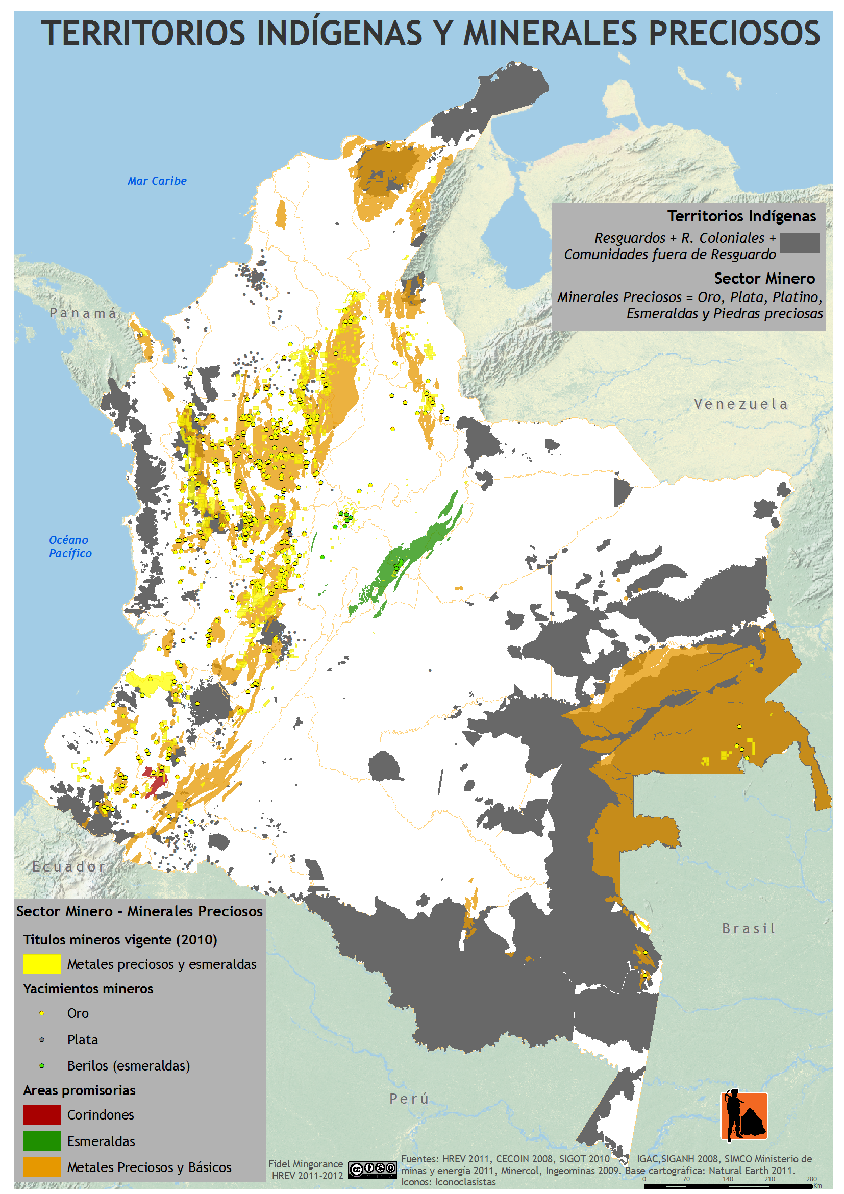
Mining activities in the Llanos Basin are restricted to certain areas, resulting in less conflicts, more common with indigenous peoples in the Amazonian part of Colombia.[61]

In San José del Guaviare platinum is mined.[65]

Mining in the Llanos Basin and surrounding areas
Resources Map Department Municipality Mine Notes
halite
Meta Restrepo Upín [63][66]
gold
Puerto Rico [62]
Arauca Arauca
gold
Guaviare San José del Guaviare
platinum, iron, albite, andradite (var: melanite), 'apatite', arfvedsonite, 'biotite', calcite, cancrinite, epidote, fluorite, 'garnet', microcline, 'monazite', nepheline, siderite, titanite, zircon [65][67]
coal
Casanare Recetor [64]

Paleontology

Compared to many fossiliferous formations in Colombia, the Llanos Basin has been lean in fossil content. Most of the basin stratigraphy is only known from wells.

Paleozoic outcrops surrounding and perforating the planar geography have provided fossils dating back to the Cambrian; the Duda and Ariarí Formations.

Several fossiliferous formations of contemporaneous depositional environments have provided many unique fossils indicative of paleoclimatic conditions; turtle fossils were described from Los Cuervos in the Cesar-Ranchería Basin, and the Mirador Formation in the Catatumbo Basin direct northwest of the Llanos Basin has provided many fossil flora.[68]

Other correlative units with surrounding basins

See also

Sources

Notes

  1. ^ More detailed: continental margin (Protero- and Paleozoic), rift basin (Mesozoic), foredeep (Paleogene and early Neogene), foreland (late Neogene to recent)
  2. ^ Depending on the definition of basement, the stratigraphic succession starts either in the Paleozoic on Proterozoic crystalline basement or Jurassic on top of both
  3. ^ The northernmost of three Colombian basins on this plate, to the south the Caguán-Putumayo and Vaupés-Amazonas Basins
  4. ^ based on Duarte et al. (2019)[46], García González et al. (2009),[47] and geological report of Villavicencio[48]
  5. ^ based on Duarte et al. (2019)[46] and the hydrocarbon potential evaluation performed by the UIS and ANH in 2009[49]

References

  1. ^ Barrero et al., 2007, p.69
  2. ^ ANH, 2010
  3. ^ García González et al., 2009, p.58
  4. ^ Pseudopaludicola llanera at IUCN.org
  5. ^ Mastigoproctus colombianus at GBIF.org
  6. ^ Paris et al., 2000a, p.36
  7. ^ Hernández Pardo et al., 2009, p.122
  8. ^ Hernández Pardo et al., 2009, p.28
  9. ^ Plancha 266, 1998
  10. ^ a b c d e f García González et al., 2009, p.27
  11. ^ a b c d e f García González et al., 2009, p.50
  12. ^ a b García González et al., 2009, p.85
  13. ^ a b c d e f g h i j Barrero et al., 2007, p.60
  14. ^ a b c d e f g h Barrero et al., 2007, p.58
  15. ^ Plancha 111, 2001, p.29
  16. ^ a b Plancha 177, 2015, p.39
  17. ^ a b Plancha 111, 2001, p.26
  18. ^ Plancha 111, 2001, p.24
  19. ^ Plancha 111, 2001, p.23
  20. ^ a b Pulido & Gómez, 2001, p.32
  21. ^ Pulido & Gómez, 2001, p.30
  22. ^ a b Pulido & Gómez, 2001, pp.21-26
  23. ^ Pulido & Gómez, 2001, p.28
  24. ^ Correa Martínez et al., 2019, p.49
  25. ^ Plancha 303, 2002, p.27
  26. ^ Terraza et al., 2008, p.22
  27. ^ Plancha 229, 2015, pp.46-55
  28. ^ Plancha 303, 2002, p.26
  29. ^ Moreno Sánchez et al., 2009, p.53
  30. ^ Mantilla Figueroa et al., 2015, p.43
  31. ^ Manosalva Sánchez et al., 2017, p.84
  32. ^ a b Plancha 303, 2002, p.24
  33. ^ a b Mantilla Figueroa et al., 2015, p.42
  34. ^ Arango Mejía et al., 2012, p.25
  35. ^ Plancha 350, 2011, p.49
  36. ^ Pulido & Gómez, 2001, pp.17-21
  37. ^ Plancha 111, 2001, p.13
  38. ^ Plancha 303, 2002, p.23
  39. ^ Plancha 348, 2015, p.38
  40. ^ Planchas 367-414, 2003, p.35
  41. ^ Toro Toro et al., 2014, p.22
  42. ^ Plancha 303, 2002, p.21
  43. ^ a b c d Bonilla et al., 2016, p.19
  44. ^ Gómez Tapias et al., 2015, p.209
  45. ^ a b Bonilla et al., 2016, p.22
  46. ^ a b Duarte et al., 2019
  47. ^ García González et al., 2009
  48. ^ Pulido & Gómez, 2001
  49. ^ García González et al., 2009, p.60
  50. ^ Producción de crudo bajó en 30.879 barriles por día en 2017 - El Tiempo
  51. ^ En 20 campos se produce el 66 % del petróleo del país - El Tiempo
  52. ^ Oil reserves per department - 2016 - ANH
  53. ^ a b Mojica et al., 2009, p.30
  54. ^ ANH & Halliburton, s.a., p.2
  55. ^ Castilla, área petrolera especial - El Tiempo
  56. ^ ANH & Halliburton, s.a., p.3
  57. ^ Chichimene
  58. ^ Las reservas de campo Quifa se reducen en 5,9 millones de barriles
  59. ^ a b Mapa de Tierras, ANH, 2017
  60. ^ Caño Limón
  61. ^ (in Spanish) Mapa de Territorios Indígenas y Minerales Preciosos
  62. ^ a b (in Spanish) Producción de oroUPME
  63. ^ a b (in Spanish) Producción de salUPME
  64. ^ a b (in Spanish) Producción de carbónUPME
  65. ^ a b (in Spanish) Producción de platinoUPME
  66. ^ Upin at Mindat.org
  67. ^ San José del Guaviare at Mindat.org
  68. ^ Jaramillo & Dilcher, 2001

Bibliography

General

  • Barrero, Dario; Pardo, Andrés; Vargas, Carlos A.; Martínez, Juan F. (2007), Colombian Sedimentary Basins: Nomenclature, Boundaries and Petroleum Geology, a New Proposal, ANH, pp. 1–92
  • García González, Mario; Mier Umaña, Ricardo; Cruz Guevara, Luis Enrique; Vásquez, Mauricio (2009), Informe Ejecutivo - evaluación del potencial hidrocarburífero de las cuencas colombianas, Universidad Industrial de Santander, pp. 1–219

Hydrodynamics

Tectonics

Petroleum

Paleontology

Reports

Maps

Departmental
Local

Further reading

Read other articles:

Universitas Raja Saud جامعة الملك سعودMotoاقْرَأْ بِاسْمِ رَبِّكَ الَّذِي خَلَقَ bacalah dengan menyebut nama tuhanmu yang menciptakan (QS 96:1)JenisPerguruan tinggi negeriDidirikan1957RektorDr. Badran A. O. Al-OmarStaf administrasi4,849Jumlah mahasiswa37,874LokasiRiyadh, Provinsi Riyadh, Arab SaudiKampus(900 ha) (9 km²)Situs webwww.ksu.edu.sa Universitas Raja Saud (Arab: جامعة الملك سعود Jami'ah al-Malik Su'ud) adalah sebuah per…

Isabella MariaIsabella karya Jean-Marc NattierKelahiran31 Desember 1741Istana Buen Retiro, Madrid, SpanyolKematian27 November 1763(1763-11-27) (umur 21)Istana Schönbrunn, Wina, AustriaPemakamanKaisergruft, Wina, AustriaWangsaWangsa Bourbon-ParmaNama lengkapIsabella Maria Louisa Antonietta Ferdinanda Josepha Saveria Dominica JoannaAyahFelipe I dari ParmaIbuMarie Louise ÉlisabethPasanganJoseph II, Kaisar Romawi Suci(pra-pengangkatan)AnakAdipati Agung Maria TheresiaAdipati Agung Maria Christ…

2021 South Korean film The Devil's DealPromotional posterHangul대외비Hanja對外秘Revised RomanizationDaeoebi Directed byLee Won-taeWritten byLee Soo-jinStarringCho Jin-woongLee Sung-minKim Mu-yeolCinematographyLee Chang-jaeProductioncompaniesTwinfilm Inc. B.A Entertainment[1]Distributed byMegabox Plus M[2]Release dates August 7, 2021 (2021-08-07) (Fantasia Fest) March 1, 2023 (2023-03-01) (South Korea) Running time116 minutesCountrySouth…

Letak Soria di Spanyol Soria merupakan kota yang terletak di sebelah utara Spanyol. Penduduknya berjumlah 37.200 jiwa (2004). Kota ini terletak di wilayah otonomi Castile-Leon. Kota ini terletak 183 km dari Madrid. Kota ini adalah ibu kota Provinsi Soria. Pranala luar Soria y más lbsMunisipalitas di Provinsi Soria30,000+ Soria 1,000+ Ágreda Almazán Arcos de Jalón Berlanga de Duero Burgo de Osma-Ciudad de Osma Covaleda Duruelo de la Sierra Ólvega San Esteban de Gormaz San Leonardo de Ya…

Community in San Diego County, California 32°43′47.02″N 117°15′09.21″W / 32.7297278°N 117.2525583°W / 32.7297278; -117.2525583 A swimming beach at the base of the Sunset Cliffs Sunset over the Pacific Ocean, as seen from Sunset Cliffs Sunset Cliffs is an affluent coastal community in the Point Loma community of San Diego, California. It is bordered by the Pacific Ocean on the west, Ocean Beach on the north, Catalina Blvd. and Santa Barbara St. on the east, and…

Process of ensuring compliance with laws, regulations, rules, standards, or social norms Enforcement is a stage in the proceedings of the SEC This article is about the socio-political concept. For other uses, see Enforcement (disambiguation). Enforcement is the proper execution of the process of ensuring compliance with laws, regulations, rules, standards, and social norms.[1] Governments attempt to effectuate successful implementation of policies by enforcing laws and regulations.[2…

Pour les articles homonymes, voir Réforme. Ne doit pas être confondu avec Calendrier grégorien. Grégoire VII, miniature du XIIe siècle. La réforme grégorienne est une politique menée durant le Moyen Âge sous l'impulsion de la papauté. Si les historiens admettent que le pape Léon IX (1049-1054) a commencé le redressement de l'Église, c'est néanmoins le pape Grégoire VII (1073-1085) qui a laissé son nom à la réforme. De plus, les efforts pour sortir l'Église …

Artikel ini sebatang kara, artinya tidak ada artikel lain yang memiliki pranala balik ke halaman ini.Bantulah menambah pranala ke artikel ini dari artikel yang berhubungan atau coba peralatan pencari pranala.Tag ini diberikan pada Oktober 2022. Beliau adalah Aus bin Abdullah bin Hujr[1] Al-Aslamiy Al-'Arajiy (Bahasa Arab : أوس بن عبد الله بن حُجر الأسلمي العرجي), penambahan al-Aslamiy di belakang namanya menyiratkan beliau adalah keturunan Bani Aslam (…

Hobart Cavanaughdalam film I Cover the Waterfront (1933)Lahir(1886-09-22)22 September 1886Virginia City, Nevada, Amerika SerikatMeninggal26 April 1950(1950-04-26) (umur 63)Woodland Hills, California, Amerika SerikatTahun aktif1928–1950Suami/istriFlorence Cavanaugh; 1 anak Hobart Cavanaugh (22 September 1886 – 26 April 1950[1]) adalah seorang pemeran karakter Amerika Serikat dalam film dan panggung. Sepanjang hidupnya, ia tampil dalam lebih dari 180 film. Refer…

Termini Imerese Tèrminicode: scn is deprecated   (Sicilian)KomuneCittà di Termini ImereseTermini ImereseLokasi Termini Imerese di ItaliaKoordinat: 37°59′14″N 13°41′46″E / 37.98722°N 13.69611°E / 37.98722; 13.69611NegaraItaliaWilayahSisiliaPemerintahan • Wali kotaFrancesco GiuntaLuas • Total77,57 km2 (2,995 sq mi)Ketinggian77 m (253 ft)Populasi (2007) • Total27.435 • Kepad…

Norwegian politician Peder HoltPeder Holt (right) makes conversation Oberst A.D. Dahl in Vadsø during the Liberation of FinnmarkGovernor of FinnmarkIn office1948 – 24 March 1963Prime MinisterEinar Gerhardsen Oscar TorpPreceded byHans GabrielsenSucceeded byKolbjørn VarmannMinister of FisheriesIn office19 November 1951 – 22 January 1955Prime MinisterOscar TorpPreceded byReidar CarlsenSucceeded byNils Lysø Personal detailsBornPeder Ragnar Holt(1899-01-25)25 January 1899Vard…

Синелобый амазон Научная классификация Домен:ЭукариотыЦарство:ЖивотныеПодцарство:ЭуметазоиБез ранга:Двусторонне-симметричныеБез ранга:ВторичноротыеТип:ХордовыеПодтип:ПозвоночныеИнфратип:ЧелюстноротыеНадкласс:ЧетвероногиеКлада:АмниотыКлада:ЗавропсидыКласс:Птиц…

Questa voce o sezione sull'argomento vescovi tedeschi non cita le fonti necessarie o quelle presenti sono insufficienti. Puoi migliorare questa voce aggiungendo citazioni da fonti attendibili secondo le linee guida sull'uso delle fonti. Luigi Antonio del Palatinato-Neuburgarcivescovo della Chiesa cattolicaJan Frans van Douven, Ritratto di Luigi Antonio del Palatinato (1690/1694); olio su tela, 79x64 cm, Galleria Palatina.  Incarichi ricoperti Gran maestro dell'Ordine teutonico (1684-16…

Constand Viljoen pada 1984 Constand Viljoen SSA SD SOE SM MMM MP (lahir 28 Oktober 1933) adalah seorang mantan komandan militer dan politikus Afrika Selatan. Ia dikenal karena menghindarkan perpecahan kekerasan bersenjata dengan mengamankan orang kulit putih Afrika Selatan sebelum pemilihan umum pasca-apartheid. Ia menikahi Christina Susanna Heckroodt dan memiliki empat putra dan seorang putri.[1] Referensi ^ Gen. Constand Viljoen. Volkstaat.net. Boerevolkstaat. …

Chemical compound 6,6-Difluoronorethisterone acetateClinical dataOther names6,6-Difluoro-17α-ethynyl-19-nortestosterone 17β-acetate; 6,6-Difluoro-17α-ethynylestr-4-en-17β-ol-3-one 17β-acetateDrug classProgestogen; Progestogen esterIdentifiers IUPAC name (1S,2R,10R,11S,14S,15S)-14-Ethynyl-8,8-difluoro-15-methyl-5-oxotetracyclo[8.7.0.02,7.011,15]heptadec-6-en-14-yl acetate CAS Number27189-18-0Chemical and physical dataFormulaC22H26F2O3Molar mass376.444 g·mol−13D model (JSmol)Interacti…

Chemical compound CilostazolClinical dataPronunciation/sɪˈlɒstəzɒl/sil-OS-tə-zol Trade namesPletalAHFS/Drugs.comMonographMedlinePlusa601038License data US DailyMed: Cilostazol Routes ofadministrationBy mouth (tablets)ATC codeB01AC23 (WHO) Legal statusLegal status AU: S4 (Prescription only) UK: POM (Prescription only) US: WARNING[1]Rx-only Pharmacokinetic dataProtein binding95–98%MetabolismLiver (CYP3A4- and CYP2C19-mediated)Elimination half…

Daniel Briere is the Flyers current general manager. The Philadelphia Flyers are a professional ice hockey team based in Philadelphia, Pennsylvania. They are members of the Metropolitan Division of the National Hockey League's (NHL) Eastern Conference.[1] The Flyers were founded in 1967 as one of six expansion teams, increasing the size of the NHL at that time to twelve teams.[2] Since the franchise was established, the team has had ten general managers,[3] including Keit…

This article is about the local government area. For the regional town, see Narrandera, New South Wales. Local government area in New South Wales, AustraliaNarrandera ShireNew South WalesLocation in New South WalesCoordinates34°45′S 146°33′E / 34.750°S 146.550°E / -34.750; 146.550Population 5,853 (2016)[1] 5,931 (2018 est.)[2] • Density1.42194/km2 (3.6828/sq mi)Established1 January 1960 (1960-01-01)Area4,116.2&#…

Cet article est une ébauche concernant le sport et la danse. Vous pouvez partager vos connaissances en l’améliorant (comment ?) selon les recommandations du projet sport. Si ce bandeau n'est plus pertinent, retirez-le. Cliquez ici pour en savoir plus. Cet article présente des problèmes à corriger. Vous pouvez aider à l'améliorer ou bien discuter des problèmes sur sa page de discussion. Certaines informations devraient être mieux reliées aux sources mentionnées dans la bibliogra…

Election For related races, see 1976 United States gubernatorial elections. 1976 New Hampshire gubernatorial election ← 1974 November 2, 1976 1978 →   Nominee Meldrim Thomson Jr. Harry V. Spanos Party Republican Democratic Popular vote 197,589 145,015 Percentage 57.66% 42.32% County results Thomson:      50-60%      60-70%      70-80% Spanos:      50-60% Governor be…

Kembali kehalaman sebelumnya