Gunung Tangkoko
| Gunung Tangkoko | |
|---|---|
 | |
| Titik tertinggi | |
| Ketinggian | 1.149 m (3.770 ft)[1] |
| Koordinat | 1°31′N 125°12′E / 1.52°N 125.20°E |
| Geografi | |
 | |
| Letak | Sulawesi, Indonesia |
| Geologi | |
| Jenis gunung | stratovolcano |
| Letusan terakhir | 1880 |
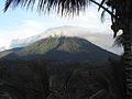
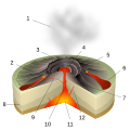
Gunung Tangkoko adalah sebuah gunung berapi di Sulawesi Utara, Indonesia. Puncak gunung memiliki kawah vulkanik. Di lereng timur terdapat kubah lava Batu Angus. Berdasarkan catatan sejarah, letusan terjadi hanya sekali ketika abad kesembilan belas.[1]
Cagar Alam Gunung Tangkoko Batuangus adalah kawasan konvervasi untuk Monyet hitam sulawesi dan Tarsius tarsier.
Galeri
-
 Gunung Tangkoko Batuangus
 -
 Puncak Tangkoko dari kiri
 -
 Pemandangan Gunung Tangkoko


Lihat pula
Referensi
- ^ a b "Tongkoko". Global Volcanism Program. Smithsonian Institution. Diarsipkan dari asli tanggal 2008-05-03. Diakses tanggal 2006-12-31.
Artikel bertopik gunung di Indonesia ini adalah sebuah rintisan. Anda dapat membantu Wikipedia dengan mengembangkannya. |
Content Disclaimer
Informasi ini disarikan dari Wikipedia dan disajikan kembali untuk tujuan edukasi. Konten tersedia di bawah lisensi CC BY-SA 3.0. Kami tidak bertanggung jawab atas ketidakakuratan data yang bersumber dari kontribusi publik tersebut.
- The information displayed on this website is sourced in part or in whole from Wikipedia and has been adapted for the purpose of restating it. We strive to provide accurate and relevant information, however:
- There is no guarantee of absolute accuracy. Wikipedia is an open, collaborative project that can be edited by anyone, so information is subject to change.
- It is not intended to constitute professional advice. The content displayed is for informational and educational purposes only. For important decisions (e.g., medical, legal, or financial), please consult a professional.
- Content copyright. Wikipedia is licensed under the Creative Commons Attribution-ShareAlike License (CC BY-SA). This means that content may be reused with appropriate attribution and shared under a similar license.
- Responsible use. Any risk arising from the use of information from this website is entirely the responsibility of the user.